CÓMO
Georreferenciar datos CAD
Resumen
La georreferenciación de datos CAD implica asignar un sistema de coordenadas y aplicar una transformación a los datos CAD. Las instrucciones proporcionadas describen cómo georreferenciar datos CAD en ArcMap.
Note:
ArcMap is in Mature support and will be retired March 1, 2026. There are no plans for future releases of ArcMap, and it is recommended that you migrate to ArcGIS Pro. See Migrate from ArcMap to ArcGIS Pro for more information.
Procedimiento
Note:
Before georeferencing the CAD data, assign the desired projection to the map to which the CAD data will be referenced. The georeferencing process writes out the projection file for the newly georefenced CAD file.
Refer to FAQ: How do I define the projection for ArcGIS data? for more information.
- En ArcMap, agregue los datos CAD al mapa.
- Abra la barra de herramientas Georreferenciación. Vaya a Personalizar > Barras de herramientas > Georreferenciación.
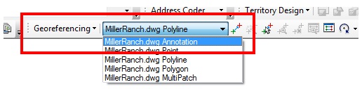
- En la barra de herramientas, seleccione la capa de entidades de CAD deseada desde el dataset.
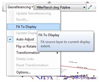
- Acérquese al área de destino deseada y vaya a Georreferenciación > Ajustar a visualización.
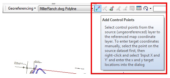
- Para crear el primer vínculo, haga clic en la herramienta Agregar puntos de control y alinee con el extremo de la entidad de parcela deseada.
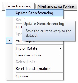
- Para guardar las actualizaciones, haga clic en Georreferenciación > Actualizar georreferenciación.
Note:
The CAD World File window displays.
- En la ventana Archivo de georreferenciación de CAD, guarde el nombre de archivo y el tipo de archivo deseados como Mundo.
- Haga clic en Guardar.
Id. de artículo: 000012808
Obtenga soporte con IA
Resuelva su problema rápidamente con el chatbot de inteligencia artificial de soporte de Esri.


Información relacionada
Descubrir más sobre este tema
Search for related information
Find training related to this topic
Explore ideas and give feedback
Obtener ayuda de expertos en ArcGIS
Empieza a chatear ahora