CÓMO
Agregar adjuntos de gran tamaño a una entidad mediante el Directorio de servicios REST de ArcGIS
Resumen
Los datos no geográficos, como documentos, imágenes y vídeos, se pueden asociar a una entidad de un mapa como adjuntos. Agregar adjuntos a una entidad se puede completar en ArcGIS Pro, Portal for ArcGIS, ArcGIS Online y ArcGIS Field Maps. Sin embargo, algunos productos de Esri, como ArcGIS Online, limitan el tamaño del archivo adjunto a 10 MB.
Como alternativa, los adjuntos se pueden agregar a través del Directorio de servicios REST de ArcGIS. De forma predeterminada, el Directorio de servicios REST de ArcGIS permite agregar adjuntos de hasta 2 GB a las entidades. Consulte API REST de ArcGIS: Cargas para obtener instrucciones sobre cómo aumentar el límite de carga.
Procedimiento
Note:
Ensure the layer allows attachments before adding them. Allow attachments in ArcGIS Pro using the Enable Attachments tool before sharing the layer as a web layer. Refer to ArcGIS Pro: Enable attachments for instructions.

Alternatively, attachments can also be enabled for features in Portal for ArcGIS. Refer to Portal for ArcGIS: Allow attachments for instructions.
- Navegue e inicie sesión en el Directorio de servicios REST de ArcGIS con la siguiente URL:
http://webadaptorhost.domain.com/webadaptorname/rest
- En Carpetas, vaya a la carpeta con el servicio de entidades alojado almacenado.
- En Servicios, haga clic en la capa de entidades alojada que contiene la capa de entidades para agregar el adjunto.
- En Capas, seleccione la capa para agregar el adjunto.
- Identifique el Id. de entidad de la capa para agregar el adjunto. El Id. de entidad es el Id. de objeto de la entidad y se puede encontrar en la tabla de atributos de la capa. Consulte Portal for ArcGIS: Mostrar tablas (Map Viewer) para obtener más información.
- Agregue el Id. de entidad y la operación addAttachment a la dirección URL como se indica a continuación:
http://webadaptorhost.domain.com/webadaptorname/rest/services/<folder_name>/<feature_service>/FeatureServer/<layer_ID>/<feature_ID>/addattachment
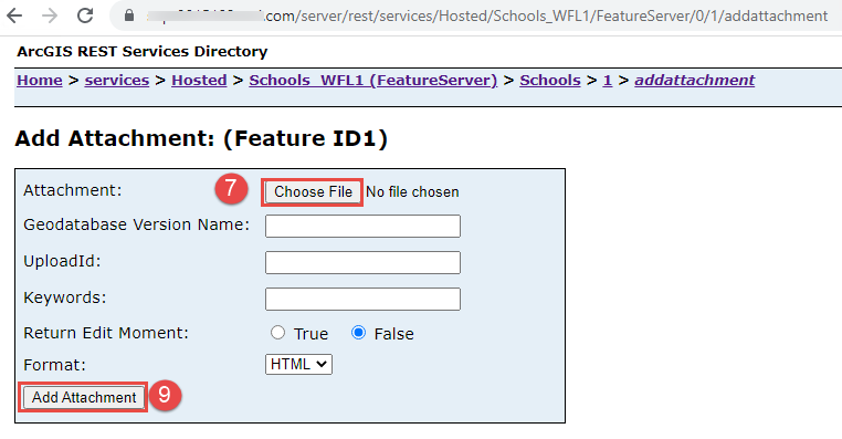
- En la página Agregar adjunto: (Id. de entidad<feature ID>), en Archivo adjunto, haga clic en Elegir archivo.
- Busque y seleccione la imagen que desea adjuntar a la entidad. Haga clic en Abrir.
- Haga clic en Agregar adjunto.
Id. de artículo: 000029873
Obtenga soporte con IA
Resuelva su problema rápidamente con el chatbot de inteligencia artificial de soporte de Esri.


Información relacionada
Descubrir más sobre este tema
Search for related information
Find training related to this topic
Explore ideas and give feedback
Obtener ayuda de expertos en ArcGIS
Empieza a chatear ahora