Barra de diálogo rápido | Soporte | Diccionario SIG
SIG de la A a la Z | Explore esta guía relacionada, que presenta términos y gráficos actualizados y ha sido desarrollada en coordinación con el equipo del Diccionario SIG de Esri.
Más información sobre SIG de la A a la Z
Diccionario SIG
Examinar diccionario
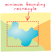
rectángulo mínimo de delimitación
Dirección URL copiadaCompartir URL
[software Esri]
Rectángulo orientado a los ejes x, y que delimita una entidad geográfica o un dataset geográfico. Se especifica mediante dos pares de coordenadas: xmin, ymin y xmax, ymax.