HOW TO
Determine the XY coordinates of line vertices in ArcGIS Pro
Summary
In ArcGIS Pro, vertices define the shape and location of the line and polygon features in a map. Precise locations can be determined by the XY coordinates of the vertices and are useful for data collections such as field samplings. In this example, the XY coordinates of the line vertices are determined in ArcGIS Pro.
This article describes three workflows involving the Edit Vertices tool, the Split Line At Vertices tool, and the Feature Vertices To Points tool to determine the XY coordinates of vertices in ArcGIS Pro.
Procedure
Use the Edit Vertices tool
- Open the ArcGIS Pro project.
- On the Edit tab, in the Features group, click Modify.
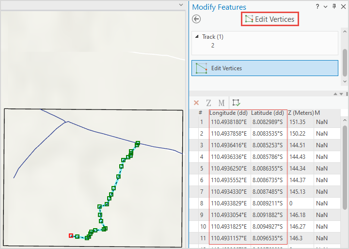
- In the Modify Features pane, search for and click Edit Vertices to open the Edit Vertices pane.
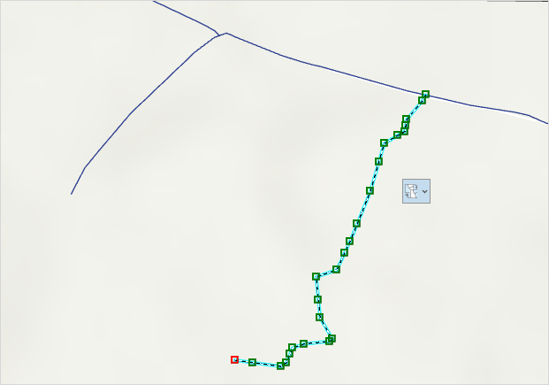
- In the map, select the line or polygon feature. The XY coordinates of the vertices are displayed in the Edit Vertices pane. In this example, the XY coordinates of the line vertices are listed in the Longitude (dd) and Latitude (dd) columns.
Use the Split Line At Vertices tool
Note:
The Split Line At Vertices tool requires an ArcGIS Desktop Advanced license.
- Open the ArcGIS Pro project.
- Use the Split Line At Vertices tool to split the line features at their vertices.
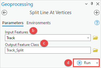
- In the Geoprocessing pane, search for and click the Split Line At Vertices tool. Refer to ArcGIS Pro: Run a tool in the Geoprocessing pane for instructions.
- In the Split Line At Vertices pane, on the Parameters tab, select the line feature layer from the Input Features drop-down list.
- Provide a name for Output Feature Class, and click Browse
 to specify the location for the output feature class.
 - Click Run.
- Add a new field for the X coordinates to the attribute table of the new feature class.
- In the Contents pane, right-click the feature layer, and click Attribute Table.
- In the attribute table, click Add Field
 .
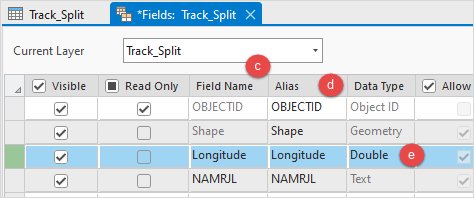
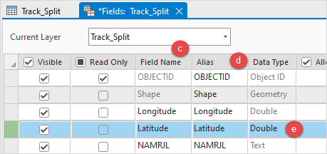
. - In the fields view, specify a name for the field in the Field Name column. In this example, the field name is Longitude.
- Double-click the Alias column of the new field and specify an alias for it.
- Double-click the Data Type column of the new field and select Double from the drop-down menu.
- On the top ribbon, on the Fields tab, click Save.
- Repeat Step 3 to add a new field for the Y coordinates to the attribute table. In this example, the field name is Latitude.
- Populate the spatial information for the X coordinates using the Calculate Geometry tool.
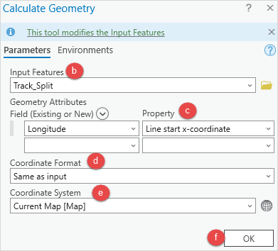
- Right-click the field header and select Calculate Geometry.
- In the Calculate Geometry window, select the feature layer created in Step 2 from the Input Features drop-down list.
- Under Geometry Attributes, select the field for Field (Existing or New), and specify Property from the drop-down list. In this example, the Line start x-coordinate is selected. Refer to ArcGIS Pro: Calculate Geometry Attributes (Data Management) for more information.
- Select the coordinate system format from the Coordinate Format drop-down list.
- Select Current Map [Map] for Coordinate System.
- Click OK.
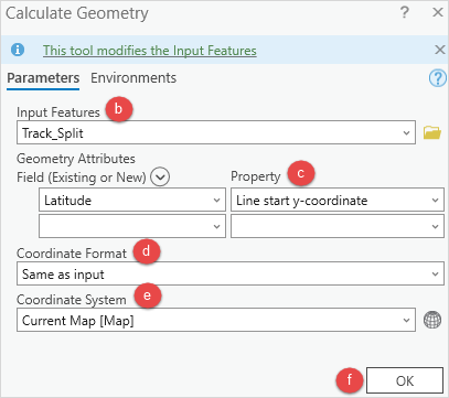
- Repeat Step 5 to populate the spatial information for the Y coordinates. In this example, Line start y-coordinate is selected for the Property parameter.
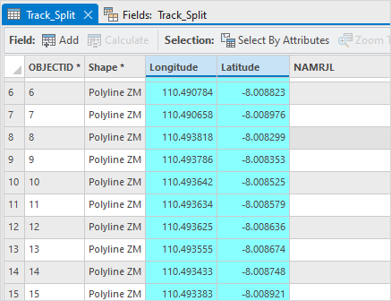
The XY coordinates of the line vertices are populated in the attribute table in ArcGIS Pro.
Use the Feature Vertices To Points tool
Note:
The Feature Vertices To Points tools requires an ArcGIS Desktop Advanced license.
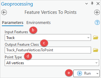
- Open the ArcGIS Pro project.
- Use the Feature Vertices To Points tool to create a point feature class generated from the vertices.
- In the Geoprocessing pane, search for and click the Feature Vertices To Points tool. Refer to ArcGIS Pro: Run a tool in the Geoprocessing pane for instructions.
- In the Feature Vertices To Points pane, on the Parameters tab, select the line feature layer from the Input Features drop-down list.
- Provide a name for Output Feature Class, and click Browse
 to specify the location for the output feature class.
 - For Point Type, select All vertices from the drop-down list.
- Click Run.
- Add a new field for the X coordinates to the attribute table of the new feature class.
- In the Contents pane, right-click the feature layer, and click Attribute Table.
- In the attribute table, click Add Field
 .
. - In the fields view, specify a name for the field in the Field Name column. In this example, the field name is Longitude.
- Double-click the Alias column of the new field and specify an alias for it.
- Double-click the Data Type column of the new field and select Double from the drop-down menu.
- On the top ribbon, on the Fields tab, click Save.
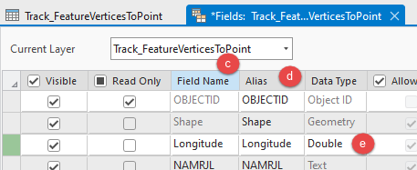
- Repeat Step 3 to add a new field for the Y coordinates to the attribute table. In this example, the field name is Latitude.

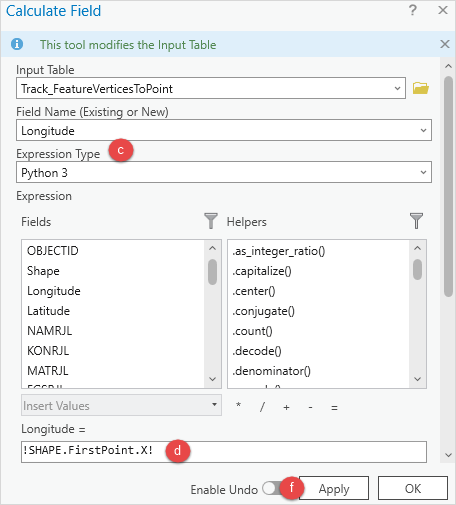
- Calculate the X coordinates field.
- Right-click the field header and select Calculate Field.
- In the Calculate Field window, the Input Table and Field Name (Existing or New) parameters are automatically selected.
- For Expression Type, select Python 3.
- Copy the following expression and paste it into the Expression box.
!SHAPE.FirstPoint.X!
- Click the Verify
 icon to validate the expression.
 - Click Apply.
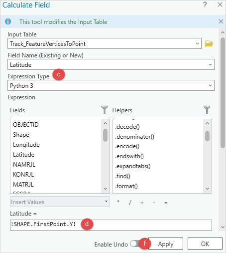
- Calculate the Y coordinates field.
- Right-click the field header and select Calculate Field.
- In the Calculate Field window, the Input Table and Field Name (Existing or New) parameters are automatically selected.
- For Expression Type, select Python 3.
- Copy the following expression and paste it into the Expression box.
!SHAPE.FirstPoint.Y!
- Click the Verify
 icon to validate the expression.
 - Click Apply.
The XY coordinates of the line vertices are populated in the attribute table in ArcGIS Pro.

Article ID: 000028277
- ArcGIS Pro 3 0
- ArcGIS Pro 2 8 x
- ArcGIS Pro 2 x
Get support with AI
Resolve your issue quickly with the Esri Support AI Chatbot.


Related Information
Discover more on this topic
Search for related information
Find training related to this topic
Explore ideas and give feedback
Get help from ArcGIS experts
Start chatting now