PROBLEM
Label size is locked relative to the map extent using Maplex Label Engine in ArcGIS Pro
Description
In ArcGIS Pro, the Maplex Label Engine is the default label engine controlling how labels are oriented and placed in a map. It also provides label-placement options for features such as streets, contour lines, and land parcels. In some cases, the labels do not dynamically adjust to the display, but are scaled according to the map extent when the map extent is changed. The label size is reduced as the map is zoomed out to a larger scale.
Cause
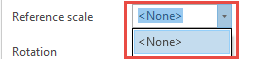
A reference scale is set for the map, causing the label size to be scaled according to the map extent. To ensure labels are not scaled and are dynamically adjusted to the same display when zooming in or out of the map, the 'Reference scale' must be set to <None>.
Solution or Workaround
Set the 'Reference scale' to <None>.
- Open the ArcGIS Pro project.
- In the Contents pane, expand Map.
- Navigate to the feature class containing the labeling data in the Contents pane.
- Ensure the feature class' Click to toggle visibility check box is checked. The map is labeled.
- Navigate to the Contents pane and right-click Map > Properties.
- In the Map Properties pane, navigate to General > Reference scale.
- In the drop-down menu, select <None>.
- Click OK.
Article ID: 000027749
- ArcGIS Pro 3 0
- ArcGIS Pro 2 8 x
- ArcGIS Pro 2 7 x
- ArcGIS Pro 2 x
Get support with AI
Resolve your issue quickly with the Esri Support AI Chatbot.


Related Information
Discover more on this topic
Search for related information
Find training related to this topic
Explore ideas and give feedback
Get help from ArcGIS experts
Start chatting now