PROBLEM
An incorrect buffer distance is generated in the output buffer layer after running the Buffer tool in ArcGIS Pro
Description
In ArcGIS Pro, the Buffer tool can be used to create a polygon that covers a given distance from a point, line, or polygon feature. Sometimes, in the output buffer polygon attribute table, the BUFF_DIST field shows random values instead of the value set when configuring the Buffer tool pane.
Cause
The coordinate system of the map frame is different from the feature layer. This issue occurs when multiple layers added to the map have different coordinate systems.
Solution or Workaround
Reproject the spatial data of the feature layer coordinate system to match the coordinate system of the current extent before running the Buffer tool.
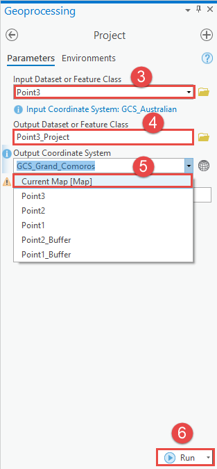
- Open the ArcGIS project.
- Navigate to Geoprocessing > Data Management Tools > Projections and Transformations > Raster > Project.
- In the Project geoprocessing pane, for Input Dataset or Feature Class, specify the feature layer to be projected.
- For Output Dataset or Feature Class, specify the output dataset in which the results are written.
- For Output Coordinate System, select Current Map [Map] from the drop-down menu.
- Click Run.
Article ID: 000027672
- ArcGIS Pro 2 8 x
- ArcGIS Pro 2 7 x
- ArcGIS Pro 2 x
Get support with AI
Resolve your issue quickly with the Esri Support AI Chatbot.


Related Information
Discover more on this topic
Search for related information
Find training related to this topic
Explore ideas and give feedback
Get help from ArcGIS experts
Start chatting now