HOW TO
Calculate the slope of a line feature across a surface in ArcGIS Pro
Summary
The properties of an elevation surface can be used to determine the slope of each segment along a line feature across the surface using the Add Surface Information tool. For example, calculating the slope of a hiking trail or a proposed road based on the spatial and elevation information derived from the raster layer. The slope of each cell of the grid is used to determine the slope of the line intersecting the cell. The tool attributes the line features with the following slope information:
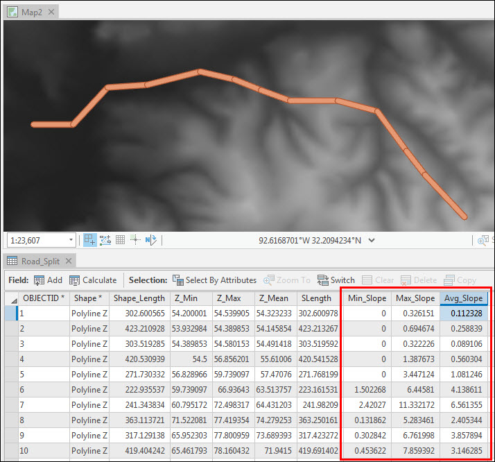
- The minimum slope is obtained from the segment with the value closest to 0, or horizontal grade.
- The maximum slope is obtained from the segment with the largest calculated value.
- The average slope is obtained by weighing each slope by its 3D length, then determining the average. This results in longer segments having a greater influence on the resulting value over shorter segments.
Procedure
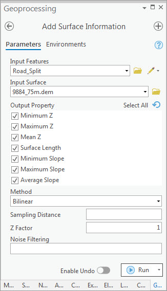
Note:
The Add Surface Information tool requires the 3D Analyst or Spatial Analyst license.
- In ArcGIS Pro, create a new project, and add the line feature class and elevation data. The elevation data can be in the form of an LAS dataset, mosaic, raster, terrain, or TIN surface.
- Optionally, split the line features at their vertices using the Split Line At Vertices tool. Splitting the lines allows the slope to be calculated for each line segment.
- Calculate the slope of the line features using the Add Surface Information tool.
- For Input Features, select the line feature class.
- For Input Surface, select the surface layer containing elevation data.
- For Output Property, check the check box for the spatial information to be written to the line feature's attribute table.
- If necessary, select a suitable interpolation method under Method.
- Click Run.
The map shows the minimum, maximum, and average slope values of each line segment in percentage (grade).
Article ID: 000025428
- ArcGIS Pro 2 7 x
- ArcGIS Pro 2 x
Get support with AI
Resolve your issue quickly with the Esri Support AI Chatbot.


Related Information
Discover more on this topic
Search for related information
Find training related to this topic
Explore ideas and give feedback
Get help from ArcGIS experts
Start chatting now