HOW TO
Publish CAD data as a hosted feature service in ArcGIS Online
Summary
Computer-aided design (CAD) data such as AutoCAD's DWG file and Bentley MicroStation's DGN file can be integrated with ArcGIS Pro maps as feature datasets. However, these file formats are not supported in ArcGIS Online, so the data must be converted to a file geodatabase feature in ArcGIS Pro before they are published as a hosted feature service to ArcGIS Online.
Procedure
- Convert the CAD dataset to a file geodatabase in ArcGIS Pro.
- On the ArcGIS Pro ribbon, click the Analysis tab > Tools.
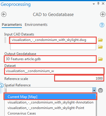
- In the Geoprocessing pane, search for the CAD To Geodatabase tool, and click it.
- For Input CAD Datasets, select the CAD dataset to be converted.
- For Output Geodatabase, specify the file geodatabase for the output dataset.
- For Dataset, specify a name for the dataset created.
- For Reference scale, specify a reference scale.
- For Spatial Reference, select Current Map [Map] from the drop-down menu.
- Click Run.
- Publish the file geodatabase to ArcGIS Online. Refer to ArcGIS Pro: Share a web feature layer using the default configuration for instructions.
Article ID:000024862
Software:
- ArcGIS Pro 2 x
- ArcGIS Pro 2 7 x
- ArcGIS Online
Get help from ArcGIS experts
Download the Esri Support App
Related Information
Discover more on this topic
Search for related information
Find training related to this topic
Explore ideas and give feedback