HOW TO
Convert a layer package to a shapefile in ArcGIS Desktop
Summary
A layer package is a zipped folder containing the layer properties and the dataset referenced by a layer. In some instances, it is required to convert all the data from a layer package to a shapefile for data analysis purposes. This article provides instructions to convert a layer package to a shapefile in ArcGIS Pro and ArcMap.
Note:
ArcMap is in Mature support and will be retired March 1, 2026. There are no plans for future releases of ArcMap, and it is recommended that you migrate to ArcGIS Pro. See Migrate from ArcMap to ArcGIS Pro for more information.
Procedure
ArcGIS Pro
Use the Export Features tool to convert a layer package to a shapefile in ArcGIS Pro.
- In ArcGIS Pro, in the Catalog tab, right-click Folders, and select Add Folder Connection.
- Select the desired folder containing the layer package file, and click OK to add the folder.
- Right-click the layer package file, and select Add To Current Map.
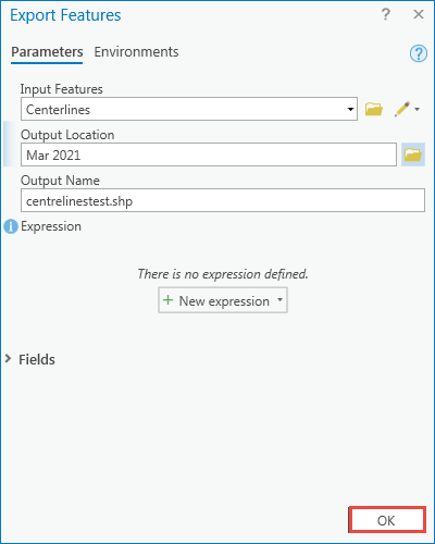
- In the Contents pane, right-click the feature layer, and navigate to Data > Export Features.
- In the Export Features window, specify the Output Location to save the output feature, and specify the Output Name.
Note:
The output location must be a non-geodatabase folder.
- Click OK to generate the shapefile.
ArcMap
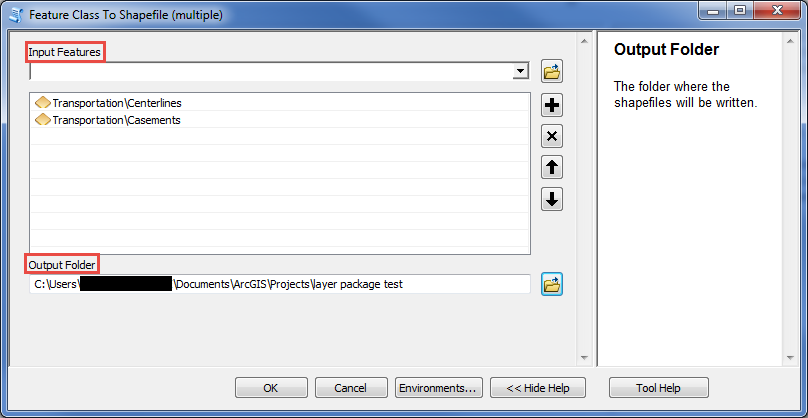
Use the Feature Class To Shapefile (multiple) tool to convert a layer package to a shapefile in ArcMap.
- In File Explorer, select and click the desired layer package file to open it in ArcMap. The image below shows an example of an ArcMap layer package file, Transportation.

- Use the Feature Class To Shapefile (multiple) tool to convert the layer package to a shapefile.
- In the Geoprocessing pane, navigate to Search for Tools.
- Search for the Feature Class to Shapefile (multiple) tool.
- For Input Features, select the desired layer package file.
- For Output Folder, click the Browse icon to specify the location.
- Click OK to generate the shapefile.
Article ID:000024418
- ArcGIS Pro 2 x
- ArcMap
Receive notifications and find solutions for new or common issues
Get summarized answers and video solutions from our new AI chatbot.


Related Information
Discover more on this topic
Search for related information
Find training related to this topic
Explore ideas and give feedback
Get help from ArcGIS experts
Download the Esri Support App