HOW TO
Publish and add the ArcGIS LocateXT Server Tool to Portal for ArcGIS
Summary
The ArcGIS LocateXT Server tool allows scanning unstructured text to create output points linked to coordinates included in the text. With this tool, the functionality of the ArcGIS LocateXT extension in desktop is made available in Portal for ArcGIS.
This article describes how to publish the ArcGIS LocateXT Server Tool to ArcGIS Server, and to add it to Portal for ArcGIS and Portal for ArcGIS Map Viewer.
Procedure
Note:
The ArcGIS LocateXT Server Tool must be downloaded and licensed before performing this workflow.
Publish the ArcGIS LocateXT Server Tool to ArcGIS Server
- In ArcMap, create the ArcGIS LocateXT Server Tool.
- In the Catalog pane, right-click My Toolboxes, and click New > Toolbox.
- Set the toolbox name as LocateXT_Tool.
- Right-click the new toolbox and click Add > Tool.
- In the Add Tool window, select the ArcGIS LocateXT Server Tool that matches the version of the ArcGIS Server. In this example, ArcGIS LocateXT Server Tool for 10.5 is selected.
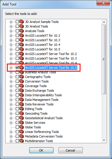
- Click OK.
- Run the ArcGIS LocateXT Server Tool for 10.x.
- Double-click ArcGIS LocateXT Server Tool for 10.x to open it.
- For Input File, select a sample text file containing coordinate values.
- For Output Feature Class, select a location for the output points.
- Accept other defaults, and click OK to run the tool.
- Share the ArcGIS LocateXT Server Tool geoprocessing result. For more information, refer to ArcGIS Server: A quick tour of publishing a geoprocessing service.
- Click the Geoprocessing tab and select Results to display the geoprocessing results.
- Right-click the ArcGIS LocateXT Server Tool result and click Share As > Geoprocessing Service.
Note:
Beginning from version 10.4, only administrators can publish a geoprocessing service. To allow publishers to publish geoprocessing services, refer to ArcGIS Server: Change geoprocessing service and service extension publishing privileges.
- In the Share as Service dialog box, select Publish a Service.
- In the Publish a Service dialog box, select the server connection, and input a valid service name. Click Next.
- Select an existing folder to publish the service, or create a new folder to store the service. Click Continue.
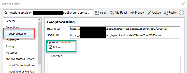
- In the Service Editor dialog box, click Geoprocessing in the left-hand pane.
- Check the Uploads check box under Operations allowed.
- Click ArcGIS LocateXT Server in the left-hand pane, and fill in the Name and Description parameters. In this example, the tool name is LocateXTServerTool.
- Click Analyze and Publish to publish the tool to ArcGIS Server.
Add the ArcGIS LocateXT Server Tool to Portal for ArcGIS and Map Viewer
- Add the ArcGIS LocateXT Server Tool to Portal for ArcGIS.
- Sign in to Portal for ArcGIS and navigate to My Content.
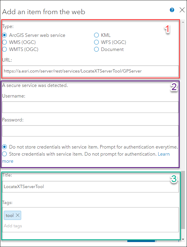
- In the My Content page, click Add Item > From a URL. The Add an item from the web window opens.
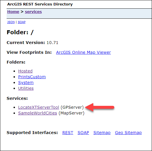
- In a new window, navigate to the ArcGIS REST Services Directory. For more information, refer to ArcGIS REST API: Using the Services Directory.
- Under Services, select LocateXTServerTool.
Note:
The ArcGIS LocateXT Server Tool name may differ from the example provided in this article, depending on the name set during the publishing process.
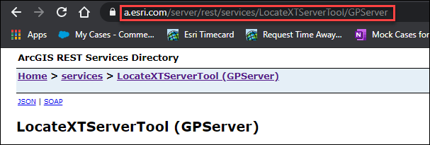
- On the LocateXTServerTool (GPServer) page, copy the URL.
- In Portal for ArcGIS, in the Add an item from the web window, select ArcGIS Server web service for Type, and paste the copied URL in the URL field.
- If necessary, provide the required login credentials.
- Provide a title and tags for the tool.
- Add the ArcGIS LocateXT Server Tool to Portal for ArcGIS Map Viewer.
- In Map Viewer, click Analysis.
- In the Perform Analysis pane, click the Browse Raster Function Templates and Custom Web Tools
 button.
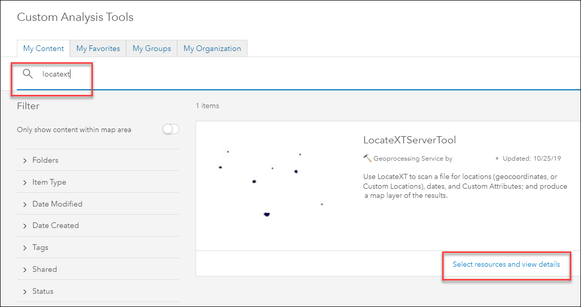
 - In the Custom Analysis Tools window, search for the ArcGIS LocateXT Server Tool and click Select resources and view details.
- On the item details page, click Select.
- In the upper right corner of the Map Viewer Analysis pane, click the back icon
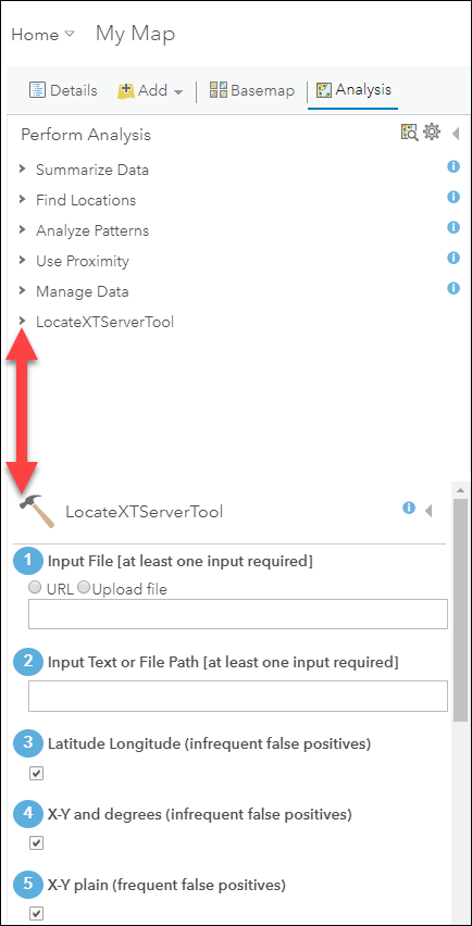
 . The ArcGIS LocateXT Server Tool is added to the list of analysis tools in the Perform Analysis pane. Expand the tool to view all the parameters required for the tool.
Article ID: 000022647
- Portal for ArcGIS
- ArcGIS Server
Get support with AI
Resolve your issue quickly with the Esri Support AI Chatbot.


Related Information
Discover more on this topic
Search for related information
Find training related to this topic
Explore ideas and give feedback
Get help from ArcGIS experts
Start chatting now