PROBLEM
The scene layer appears to be floating or sinking in 3D view in Drone2Map for ArcGIS
Description
After processing 3D products in Drone2Map for ArcGIS, the data does not display as expected on the surface in 3D view. The scene layer appears to be floating or sinking in the viewer.
Cause
The vertical spatial reference of the imagery is set improperly and/or the operator used the incorrect reference.
Solution or Workaround
Depending on the camera and/or drone, the reference must be one of the three reference types:
- Above Ground level (AGL)
- Ellipsoid/Spheroid (HAE)
- Geoid or Sea level (MSL).
Note:
It is recommended to identify the vertical reference used by the drone. Collect a test photo with the drone still on the ground, preferably on top of a marked photo control point used in the project. The altitude or z-value of the test photo can help to determine the vertical reference.
If the z-value is 0, the vertical reference is AGL. In Drone2Map, use No Conversion as the reference, or the option to Adjust image altitudes to correct the z-values.
If the z-value is not 0, identify the reference for the z-value of the test by using the following service layer (Subscriber Content): Terrain: Ellipsoidal Height. Follow the steps below:
Note:
To view the Subscriber Content, an ArcGIS Online organizational account is required.
- Open the service layer in ArcGIS Online Map Viewer.
- In the map, navigate to the location identified from the test. Click the location in the map and view the pop-up.
- Compare the user's elevation value of the test to the information in the pop-up. The image below shows an example:
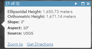
- If the value is closer to the Ellipsoidal Height, use WGS84 Ellipsoid (HAE) in Drone2Map for ArcGIS.
- If the value is closer to the Orthometric Height (+/- 1 meter), use EGM96 (MSL).
Note:
If the image heights are relative to the ground (AGL), check the settings in the mission planning software to see if there are options for referencing the EGM geoids or an ellipsoid instead. It is not advisable to use heights that are relative to ground.
Article ID: 000018495
- ArcGIS Drone2Map
Get support with AI
Resolve your issue quickly with the Esri Support AI Chatbot.


Related Information
Discover more on this topic
Search for related information
Find training related to this topic
Explore ideas and give feedback
Get help from ArcGIS experts
Start chatting now