PROBLEM
3D models display at incorrect locations on a map when exported from IFC data using the Data Interoperability Extension in ArcGIS Pro
Description
Industry Foundation Classes (IFC) is a construction-specific data model containing 3D building models imported from building information modelling software such as Revit. IFC data containing 3D building models can be exported to a file geodatabase using the Quick Import tool in the Data Interoperability toolbox in ArcGIS Pro. However, when exporting the IFC data to a file geodatabase, the 3D building models do not display at correct locations on the map. In some instances, the 3D building models disappear when converted to a 3D scene view.
Cause
The following are two possible causes:
- The IFC data is not georeferenced. The geographic coordinates are not set for the 3D building models in the IFC data.
- The elevation for the 3D building models is not set.
Solution or Workaround
Set the elevation properties of the IFC layer to display on the ground so the models appear at the correct location on the map, and enable underground navigation for the IFC surface layer so the models appear in 3D Scene Viewer. Follow the instructions described below:
Set the elevation properties of the IFC layer (applicable for ArcGIS Pro 2.x)
- In the Contents pane, right-click the IFC layer and click Properties.
- In the Layer Properties dialog box, select Elevation.
- Click the Features are drop-down arrow and select On the ground. Click OK.
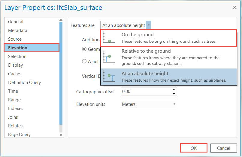
Note:
To check if the elevation is set correctly, convert the map to a 3D scene view. If the elevation is not set, the 3D building models may not appear.
Enable underground navigation for the IFC surface layer
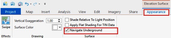
For ArcGIS Pro 2.2 and above:- In the Contents pane, select the desired IFC layer.
- Click the Appearance tab and check the Navigate Underground text box.
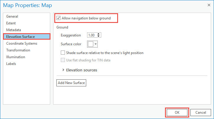
- In the Contents pane, right-click Scene and click Properties.
- In the Map Properties: Scene dialog box, click Elevation Surface.
- Check the Allow navigation below ground text box and click OK.
Note:
To check if the 3D building models are displayed at the correct locations, use the Zoom To Layer tool.
Article ID:000018235
- ArcGIS Pro
Get help from ArcGIS experts
Download the Esri Support App
Related Information
Discover more on this topic
Search for related information
Find training related to this topic
Explore ideas and give feedback