PROBLEM
An exported PDF map document with Data Driven Pages enabled displays a different map scale
Description
In ArcMap, when exporting and printing a MXD document with Data Driven Pages functionality to PDF, the map scale changes.
Cause
This problem can occur due to any of the following causes:
- The MXD document has index layers with different fixed map scales. The map scales are changed when exporting to PDF.
- Switching the MXD document from layout view to data view or from a data view to layout view before exporting or printing the map changes the map scale. When a MXD document is in data view, the map scale follows the data display but is not dependent on the page size of the printer. Whereas in layout view, the map scale follows the page size used to print. The difference in the map scale between the data view and layout view is proportionate to the page size selected.
Solution or Workaround
Disable the Data Driven Pages functionality. Use the Fixed Scale option in Data Frame Properties. Follow the instructions described below.
Note:
Uncheck the Enable Data Driven Pages box in the Setup Data Driven Pages dialog box. For more information, refer to ArcMap Web Help: Enabling Data Driven Pages.
- In the Table Of Contents, right-click the data frame and click Properties.
- Navigate to Data Frame > Extent and click Fixed Scale.
- Click the Scale drop-down arrow and select the most suitable map scale in the list.
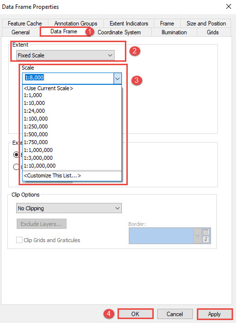
Note:
Optionally, type the desired map scale in the Scale text box.
- Click Apply > OK to view the map scale on the exported PDF map document.
Article ID:000018122
Software:
- ArcMap
Get help from ArcGIS experts
Download the Esri Support App
Related Information
Discover more on this topic
Search for related information
Find training related to this topic
Explore ideas and give feedback