HOW TO
Calculate longitude and latitude points for a parcel fabric in ArcMap
Summary
A parcel fabric is used to edit cadastral information with a geospatially integrated data model and allows users to store significant data, for instance land records and data layers. Therefore, it is important to add longitude and latitude points to identify the land locations on a map.
Procedure
There are two options to calculate longitude and latitude points to a parcel fabric in ArcMap:
- Calculate the centroid of the parcel and add the longitude and latitude points to the centroid
The geometric centre (centre of mass) of the parcel is calculated using the weighted mean centre of the parcel. The centroid of the parcel is calculated using the Feature to Point tool which generates the output point at the centroid of the parcel. For more information, refer to ArcMap Web Help: Feature To Point.
Note:
The Feature To Point tool is only available for the Advanced license level. For more information, refer to ArcMap Web Help: Licensing information.
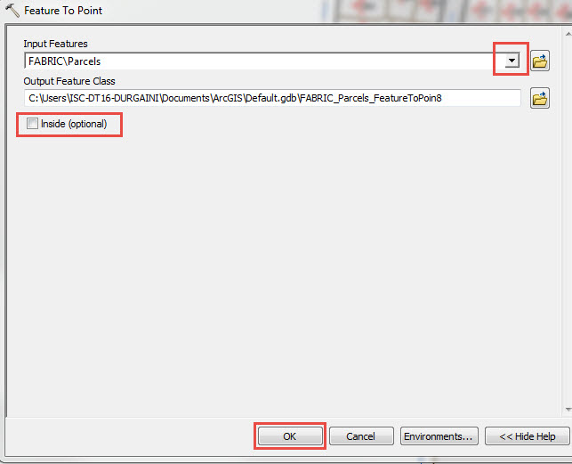
- In ArcToolbox, double-click the Data Management Tools > Features > Feature To Point.
- In the Feature To Point dialog box, click the Input Features drop-down arrow and select the parcel feature.
- In the Output Feature Class text box, set the output point feature class location.
Note:
Optionally, check the Inside (optional) check box. For more information on the Inside option, refer to ArcMap Web Help: Usage.
- Click OK.
- Navigate back to ArcToolbox and click Add XY Coordinates.
- In the Add XY Coordinates dialog box, click the Input Features drop-down arrow and select the newly created point feature class obtained from the Feature To Point tool.
- Click OK.
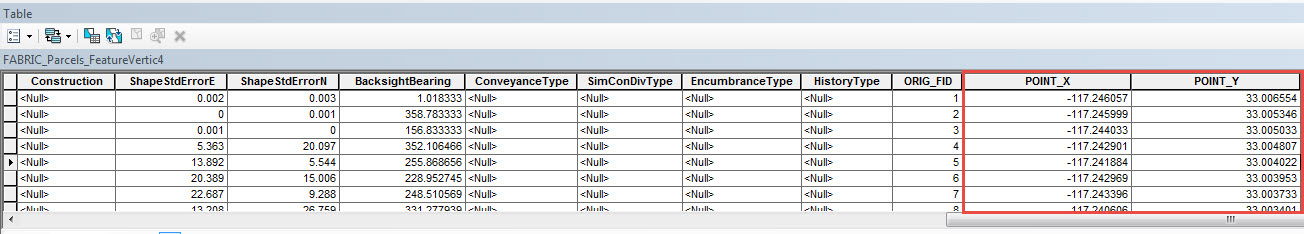
- In the Table of Contents, right-click the newly created point feature class and click Open Attribute Table to view the longitude and latitude points.
- Convert the vertices of the parcel to points and add the latitude and longitude to the vertex points
Note:
The Feature Vertices To Points tool is only available for the Advanced license level. For more information, refer to ArcMap Web Help: Licensing information.
The vertices of the parcel fabric are converted to vertex points using the Feature Vertices To Points tool, creating a vertex point on the boundaries of the parcel fabric. For more information, refer to ArcMap Web Help: Feature Vertices To Points.
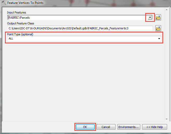
- In ArcToolbox, double-click the Data Management Tools > Features > Feature Vertices To Points.
- In the Feature To Point dialog box, click the Input Features drop-down arrow and select the parcel feature.
- In the Output Feature Class text box, set the output point feature class location.
Note:
Optionally, click the Point Type (optional) drop-down arrow to select the type of points required. For more information on this option, refer to ArcMap Web Help: Syntax.
- Click OK.
- Navigate back to ArcToolbox, click Add XY Coordinates.
- In the Add XY Coordinates dialog box, click the Input Features drop-down arrow and select the newly created point feature class obtained from the Feature Vertices To Points tool.
- Click OK.
- In the Table of Contents, right-click the newly created point feature class and click Open Attribute Table to view the longitude and latitude points.
Article ID:000017586
- ArcMap
Get help from ArcGIS experts
Download the Esri Support App
Related Information
Discover more on this topic
Search for related information
Find training related to this topic
Explore ideas and give feedback