Frequently asked question
What do I need to know about GDA2020 and ArcGIS?
Australia is moving towards a new coordinate system, Geocentric Datum of Australia 2020 (GDA2020), to facilitate a more robust, accurate, and capable datum which is more closely aligned to global positioning systems like GNSS. This will ensure that Australian industry, the research community, and the public can accurately align themselves and their data. The new GDA2020 datum has been launched by Geoscience Australia and the Intergovernmental Committee on Survey and Mapping (ICSM) on the 15th of December, 2017. The current existing national geodetic datum, Geocentric Datum of Australia 1994 (GDA94), is not capable of meeting the expectations of a modern technical GPS connected Australia. The Australian Government has committed $225 million to provide 5-10 centimeter accurate positioning and it is a significant improvement from the 5-10 meter accuracy currently achievable using GPS enabled devices.
The introduction of GDA2020 has brought additional requirements and considerations for both software providers and users. Esri and Esri Australia have been working closely with ICSM and Geoscience Australia to ensure that ArcGIS software products support the new definitions. With the delivery of ArcGIS Pro 2.2 and ArcGIS 10.6.1, Esri now fully supports GDA2020 and the GDA2020 National Transformation version 2 (NTv2) transformation grid files out of the box.
Introduction of GDA2020 to ArcGIS software
The introduction of a new coordinate system impacts all areas of the software. The Esri support for GDA2020 was progressively added as the coordinate system and associated transformation methods were released.
- ArcGIS 10.5 and ArcGIS Pro 2.0 introduced the GDA2020 coordinate system. It became visible under Coordinate System and allowed new data to be collected within this spatial reference. However, the transformation methods were not available at the time and existing data could not be projected to GDA2020.
- ArcGIS 10.6 and ArcGIS Pro 2.1 introduced the mathematical seven parameter similarity transformation. ICSM also developed two 2D national transformation grids for GDA1994-GDA2020 that were not released with the software. They could be manually included by downloading the grid files, renaming them, and placing them into the appropriate product directory.
- With ArcGIS 10.6.1 and ArcGIS Pro 2.2, Esri now includes GDA2020 as a coordinate system and supports GDA2020 NTv2 files through a separate installation through My Esri > My Organizations > Downloads > Data and Content > ArcGIS Coordinate Systems Data.
Note:
GDA2020 is not supported in earlier versions of ArcGIS with the exception of the ArcGIS 10.2.1 utility version.
GDA1994-GDA2020 transformation
A geographic transformation is a mathematical operation that converts the coordinates of a point in one geographic coordinate system to the coordinates of the same point in another geographic coordinate system. A grid-based transformation method can be very accurate in modeling small changes between two geographic coordinate systems. Grid files can be reasonably large. The ICSM released two 2D national transformation grids as follows:
- Conformal: A grid version of the seven parameter similarity transformation. The basic difference between GDA94 and GDA2020 coordinates primarily due to plate tectonic movement (approximately 1.7m NNE over 26 years); and
- Conformal + Distortion: Incorporates the conformal seven parameter similarity transformation plus localized and regional distortion revealed by incorporating coordinates on the ground survey control networks across the nation.
Due to the size of these grids, they are available as a separate installation through My Esri for ArcGIS 10.6.1 and ArcGIS Pro 2.2. They are also available directly from the ICSM GitHub site.
There are three available transformation methods between GDA1994 and GDA2020 when working with a supported release and the NTv2 transformation grids have been applied:
- GDA_1994_To_GDA2020_1: Seven parameter similarity transformation.
- GDA_1994_To_GDA2020_NTv2_C: Conformal grid.
- GDA_1994_To_GDA2020_NTv2_CD: Conformal + Distortion grid.
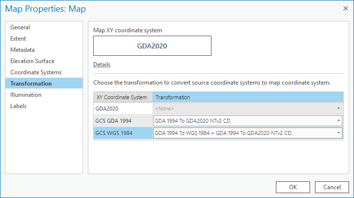
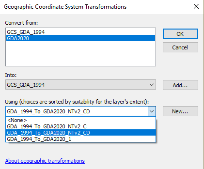
As the software is not delivered with grid files, only the seven parameter similarity transformation will appear in ArcGIS until the grid files are loaded into the product directories. Users must ensure that an appropriate transformation method is applied to the map or data frame when displaying GDA94 data in a GDA2020 data frame or vice versa. The geographic coordinate system transformation methods are shown in the images below:
- ArcGIS Pro:
- ArcMap:
GDA2020 and web GIS
Web GIS by default displays data in WGS 1984 Web Mercator (Auxiliary Sphere) with data often re-projected on the fly to the web projection to align with the basemap and fit the global projection. GDA94 and WGS84 are generally interchangeable with little effect on positional accuracy. Unfortunately, with the modernization of the Australian datum to GDA2020, there is not a definitive relationship between GDA2020 and WGS84. This results in any transformation between GDA2020 and WGS84 having an error of 3 meters or greater.
Data in the web map environment can be displayed against Esri basemaps and web scenes and other WGS84-based data. In most instances, this will not be an issue as the generic basemap data is derived from many sources with varying positional accuracies.
From a user data perspective, Esri Australia recommends the following:
- Transform all data to GDA2020 and republish to web GIS in GDA2020 or a GDA2020-based projected coordinate system.
- When publishing to WGS84, utilize the projection path GDA2020 to GDA94. Data will be published with GDA94 accuracy and coordinate transformations between WGS84 and GDA94 can be performed.
- Create basemaps (Imagery, Street, and Topographic) in GDA2020.
- Do not mix data from GDA94 and GDA2020 in web GIS as there will be a 1.8 meters alignment error.
- If a coordinate conversion is required in web GIS from WGS84 to GDA2020, utilize the transformation path of WGS84 to GDA94 to GDA2020.
Article ID: 000017504
- ArcMap
- ArcGIS Pro 2 x
Get support with AI
Resolve your issue quickly with the Esri Support AI Chatbot.


Related Information
Discover more on this topic
Search for related information
Find training related to this topic
Explore ideas and give feedback
Get help from ArcGIS experts
Start chatting now