Frequently asked question
Why is the distance measured using the scale bar in ArcMap different from the distance measured in Business Analyst Online?
Answer
The scale bar in ArcMap utilizes a planar (flat earth) method when measuring distance and does not take into account the curvature of the earth. The planar method uses 2D Cartesian mathematics to calculate lengths and areas.
Meanwhile, Business Analyst Online utilizes the geodesic (spheroid) method when measuring distance which takes into account the curvature of the earth and measures using an algorithm based on the WGS 1984 Web Mercator (Auxiliary Sphere) projection to give an accurate measurement.
For example, when creating a five miles ring from a point in Business Analyst Online, a circle is drawn around the point on a 2D surface that represents a 3D sphere, measuring five miles in all directions to create a ring. However, when using the scale bar in ArcMap to measure the same extent, the measurement displayed on the scale bar is larger than five miles depending on the location of the measured distance on the map.
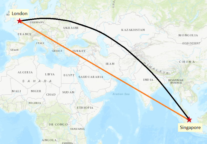
The image below shows an example of a planar distance and the geodesic equivalent of the planar distance. The geodesic line represents the actual path taken when travelling between London and Singapore.
The measurement discrepancy between measuring in Business Analyst Online and the scale bar in ArcMap increases as the measured feature is farther from the equator due to the WGS 1984 Web Mercator (Auxiliary Sphere) projection used in Business Analyst Online. WGS 1984 Web Mercator (Auxiliary Sphere) uses a conformal projection, which preserves direction and the shape of data but distorts distance and area, with the greatest distortion in the north-south direction.
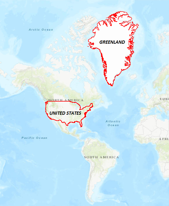
It is not possible to get a 3D globe onto a 2D surface while preserving all map properties, such as area, shape, direction, and distance. For example, the distortion of the WGS 1984 Web Mercator (Auxiliary Sphere) projection can be seen by comparing the size of Greenland to that of the United States on Esri maps. Greenland appears to be more much larger visually compared to the United States, even though the United States is roughly three times larger than Greenland. The same is true for Russia, Canada, Alaska, Antarctica, and other extreme northern and southern features. The following image compares the area of Greenland and the United States on the map in a WGS 1984 Web Mercator (Auxiliary Sphere) projection:
Refer to the following article for more information on the WGS 1984 Web Mercator (Auxiliary Sphere) projection, FAQ: Why are my map, distance and area measurements wrong when using WGS 1984 Web Mercator?. To get the same distance measurement in ArcMap as measured in Business Analyst Online, use the Measure tool and set the measurement type to Geodesic.
Article ID:000016668
- ArcMap
- ArcGIS Business Analyst Web App
Get help from ArcGIS experts
Download the Esri Support App
Related Information
Discover more on this topic
Search for related information
Find training related to this topic
Explore ideas and give feedback