PROBLEM
A generic error is returned when running the Create Accuracy Assessment Points tool in ArcMap
Description
The Create Accuracy Assessment Points tool creates randomly sampled points for a classified dataset which are used as the input points for the accuracy assessment workflow.
In some instances, running the Create Accuracy Assessment Points tool returns the generic error, "Error 999999: Error executing function."
Note:
Running the geoprocessing tools in the accuracy assessment workflow requires a license for the Spatial Analyst extension.
Cause
The following are possible causes for the issue, depending on the type of the classified dataset (raster or feature class data) used as the input for the tool.
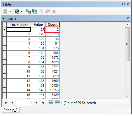
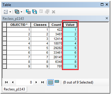
- The input classified dataset (raster or feature class data) does not have an integer data type field with the name Value.
Classifying an image in ArcMap using the Image Classification toolbar and workflow automatically represents classes of the image by integers in a field named Value. For example, bare ground may be represented as 1, vegetation represented as 2, and built areas represented as 3, depending on how the analysis is run. Images classified through other means may use different field names, data types, and codes to represent classes, thus causing errors when working through the accuracy assessment workflow as the tools in the accuracy assessment workflow only detect and interpret classes in the integer format within a field named Value.
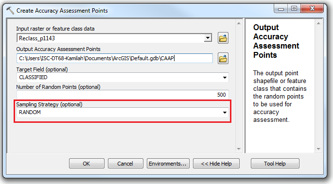
- The Stratified Random or Equalized Stratified Random sampling strategy is selected for an input classified raster data that has at least one class with pixel counts less than 10.
Solution or Workaround
Use one of the following solutions, according to the causes stated above, to solve the problem.
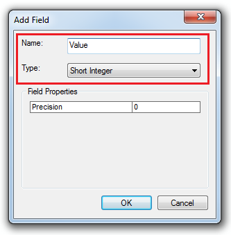
- Create a new field in the classified dataset with the name Value, and set the data type to Integer. Assign integer values to the created Value field, ensuring each class is given its own unique integer value as an identifier. Refer to the following document for steps to create a new field: Adding fields.
- Use the Random sampling strategy if the input is a classified raster with at least one class that has a pixel count less than 10.
Article ID: 000016488
- ArcMap
Get support with AI
Resolve your issue quickly with the Esri Support AI Chatbot.


Related Information
Discover more on this topic
Search for related information
Find training related to this topic
Explore ideas and give feedback
Get help from ArcGIS experts
Start chatting now