HOW TO
Measure line direction interactively in ArcMap
Summary
The direction of a line feature can be measured interactively in ArcMap in the following direction measuring systems:
- north azimuth
- south azimuth
- quadrant bearing
- polar
Procedure
The line is measured in editing mode. Therefore, the line feature layer has to be editable. Before starting measuring: Select one of the following two workflows based on the license level of the software:With a Standard or Advanced license
- Add COGO to ArcMap toobar: right-click at the blank space on ArcMap toolbar, and click COGO. The COGO toolbar is added to ArcMap.
- Click COGO Report (the seventh tool from the left on the COGO toolbar). This opens the COGO Report dialog box:
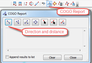
- Click Direction and distance of a line in COGO Report dialog box.
- On the map, click the start point of the line and then click the end point. The direction and distance are reported in the COGO Report dialog.
With a Basic license
- On the Editor toolbar, click the Create Feature button
 and select the Line Construction Tool in Create Features dialog.
 - Click the start point of the line, and move the mouse to snap to the end point of the line, then right-click and left-click Direction. The direction of the line is shown in the pop-up.
- Close the pop-up, right-click again, and click Delete Sketch.
Article ID:000015374
Software:
- ArcMap
Get help from ArcGIS experts
Download the Esri Support App
Related Information
Discover more on this topic
Search for related information
Find training related to this topic
Explore ideas and give feedback