PROBLEM
A lidar file is incorrectly projected
Description
When adding a lidar (.las) file to an existing project in ArcMap, the lidar file does not display in the correct location, even if the projection is defined.
Cause
This issue occurs due to an incorrect spatial reference contained in the .las file header. It is not possible to fix the projection within the lidar file, however, this can be done by adding a projection (.prj) file that defines the coordinate system of the .las file.
Solution or Workaround
The following instructions describe how to fix an incorrectly projected lidar file to be used for spatial analysis.
Note:
The core toolboxes available in ArcMap do not contain a tool for adding a .prj file to a lidar file. 3D Samples Toolbox for ArcGIS Desktop is only available in versions 10.2 to 10.6. If the downloaded 3D Sample tools do not run as designated, please leave a comment on the toolbox page.
- Download 3D Sample Tools.
- Locate and open the downloaded 3D Samples .zip file, and install the 3D Samples.exe file.
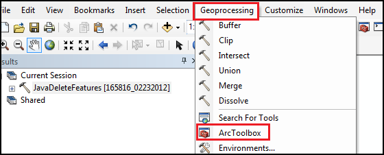
- In ArcMap, add the 3D Samples toolbox to the ArcToolbox. To add the toolbox:
- On the ArcMap main menu, click the Geoprocessing menu > ArcToolbox.
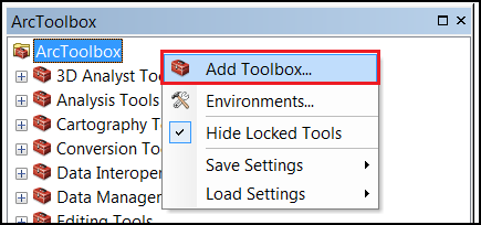
- Right-click the ArcToolbox shortcut menu > Add Toolbox.
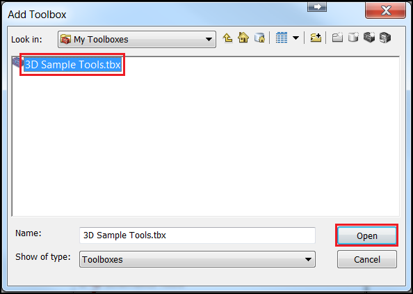
- In the Add Toolbox dialog, select Toolboxes from the Look In drop-down menu, double-click My Toolboxes > 3D Sample Tools.tbx, and click Open.
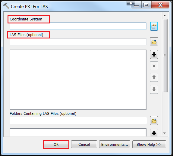
- In ArcToolbox, navigate to 3D Sample Tools > Lidar Management, and open the Create PRJ for LAS tool.
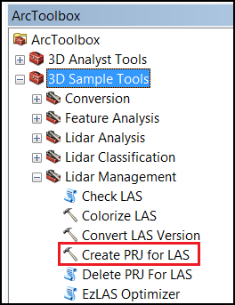
Note:
In some instances, the Create PRJ for LAS tool may not be available in the toolbox. Refer to ArcMap: Create LAS Dataset for more information.
- Set the coordinate system and the .las file. The tool allows for the selected coordinate system to be applied to multiple .las files, or even a whole folder of .las files at one time.
- Click OK to run the tool. A .prj file with the same name as the input .las file is created, allowing ArcMap to read and apply the correct projection.
Note:
The projection file does not change the underlying projection stored in the .las, but allows ArcMap to override the underlying projection to ensure the .las displays correctly and can be used for spatial analysis.
Article ID:000014624
- ArcMap
Get help from ArcGIS experts
Download the Esri Support App
Related Information
Discover more on this topic
Search for related information
Find training related to this topic
Explore ideas and give feedback