PROBLEM
Feature points do not display in the map when XY values are added directly to the attribute table of a feature class
Description
In ArcMap, feature points do not display in the map when an edit session is started and XY values are added directly to the attribute table of a feature class. A new record is added in the attribute table with the XY values, but the feature points do not display.
Cause
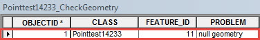
It may be assumed that adding the XY coordinates manually into the attribute table display the point features. However, the point features do not display in the map because of null geometry values. The data values do not have any geometry for ArcMap to recognize and display the points, which leads to null geometry values.
The Check Geometry tool can be used to find which record has null geometry. For more information on Check Geometry tool, refer to ArcMap Web Help: Check Geometry.
Solution or Workaround
There are two options to display new XY data points in ArcMap as described below:
Export and edit the attribute table in Microsoft Excel- In ArcMap, export the attribute table to Microsoft Excel. For more detailed steps, refer to the following article: How To: Export an attribute table to Microsoft Excel
- In Microsoft Excel, add the new XY coordinate values.
- Add the attribute table back to ArcMap after editing the attribute table in Microsoft Excel. For more detailed steps, refer to: ArcMap Web Help: Adding a Microsoft Excel table to ArcMap
- In ArcMap, start an edit session on the point feature layer.
- Click the Create Features button.
- Right-click the map and click Absolute X,Y.
Note:
Refer to ArcMap: Creating a point or vertex at an exact x,y location (absolute x,y) for more detailed steps.
- Edit the attribute table manually by adding the XY coordinate values in the X and Y column respectively.
Note:
The Calculate Geometry tool can also be used to add the desired XY coordinates in the attribute table. Refer to: ArcMap: Calculating area, length, and other geometric properties for more detailed steps.
Article ID:000014233
- ArcMap
Get help from ArcGIS experts
Download the Esri Support App
Related Information
Discover more on this topic
Search for related information
Find training related to this topic
Explore ideas and give feedback