HOW TO
Append spatial coordinates into a CSV file containing addresses using ArcGIS Online
Summary
With only an ArcGIS Online subscription and without access to ArcGIS Desktop, coordinates of x-y data can be incorporated the into a CSV file of addresses. The instructions provided describe how to do this.
Procedure
There are two methods to append spatial coordinates into a CSV file containing addresses using ArcGIS Online. Either use the Export Data function or use the Extract Data function.- Using the Export Data function
- Log in to ArcGIS.com.
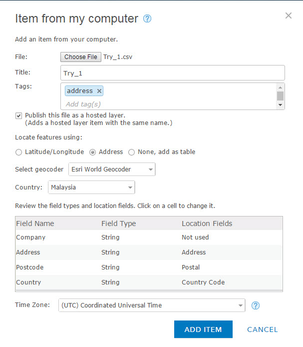
- Go to My Content, click Add Item to add the CSV file. For more information refer to the following link: ArcGIS Online Help: Add files from your computer
- Upload a CSV file containing addresses to a web map in ArcGIS Online.
- In the Item from my computer dialog box, ensure that the Title and Tags fields are filled out, select the desired geocoder and country, and click ADD ITEM.
The added CSV layer appears as a hosted feature layer.
- In the item details page, there are two ways to export the file to a CSV file.
- Via the Layers section
- Export Data > Export to CSV file.
- In the Export to CSV file dialog, fill in the details and click Export.
- In the item details page, click Download.
- Via the Layers section
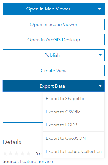
- By clicking Export Data
- Layers > Export To > Export to CSV file.
- In the Export to CSV file dialog, fill in the details and click Export.
- In the item details page, click Download.
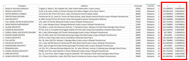
- Open the downloaded CSV file. The X and Y fields are added.
- Using the Extract Data function
- Log in to Arcgis.com.
- Repeat steps 2, 3, and 4 of the previous procedure to add the .CSV file to ArcGIS Online.
- In the item details page, hover the cursor over the thumbnail and click Open in Map Viewer.
- In the map viewer page, click Analysis > Manage Data > Extract Data.
- Select the desired file in the Layers to extract box.
- Ensure that the output data format and output file name are saved in the desired account, and click RUN ANALYSIS.
The data extracted is available in My Content. - Navigate to My Content, and select the desired CSV file.
- In the item details page, click Download.
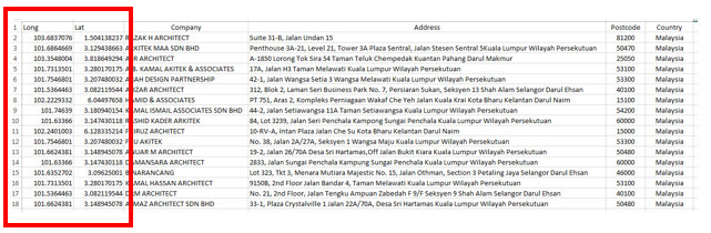
- Open the downloaded CSV file. The Long and Lat fields are added.
Article ID:000013606
Software:
- ArcGIS Online
Get help from ArcGIS experts
Download the Esri Support App
Related Information
Discover more on this topic
Search for related information
Find training related to this topic
Explore ideas and give feedback