Frequently asked question
How does the Projection Engine list available geographic (datum) transformations, and why is the drop-down sometimes blank?
Answer
This article explains the criteria used by the Projection Engine to sort and select the appropriate geographic (datum) transformation from the available options, and create the drop-down lists of suggested transformations in the dialog box.
The Projection Engine (PE) is a developer’s library that supports predefined and application-defined coordinate systems and isolates map projection and datum-handling code into a compact and integrated program for managing coordinate systems through a well-defined API. The PE is responsible for sorting the available transformations and selecting the best transformation between Geographic Coordinate Systems (GCS) for a specific area.
Here are the criteria applied to create the transformation list:
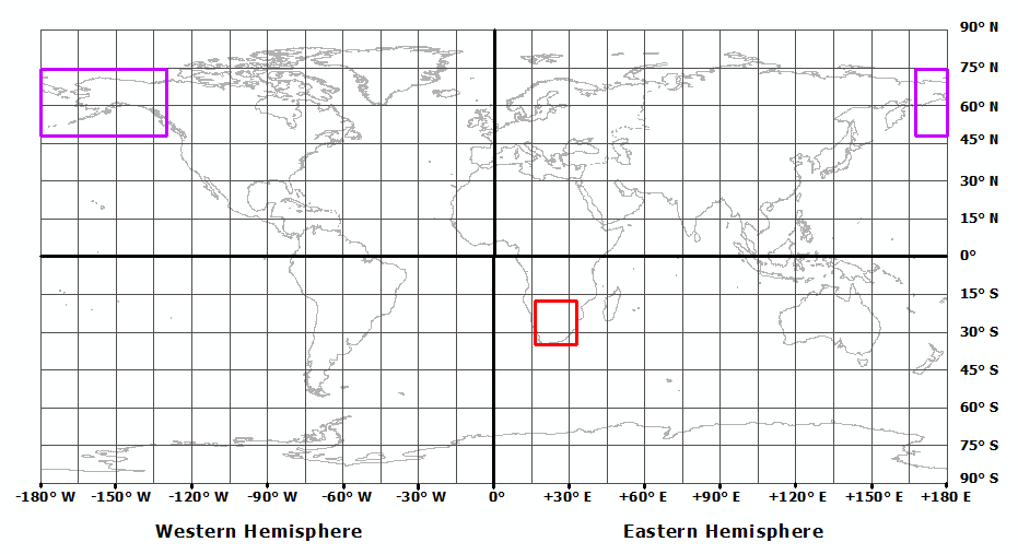
- The software examines the extents of the geographic coordinate system (GCS) defined for the data and determines the type of intersection. There are two types of intersections: 1-part and 2-part.
If the GCS and datum are all within one hemisphere, either the Eastern which extends from 0 to +180, or the Western which extends from 0 to -180, the intersection requires a 1-part transformation. One example is the Geographic Coordinate System, GCS_Cape, which is used in southern Africa, appearing as a red square in the image below. The extent of this GCS is in the Eastern Hemisphere.
If the GCS and datum cross the -180/+180 boundary, the intersection requires a 2-part transformation. Portions of the North American Datum 1983 Alaska, that appears in the image as purple rectangles, appear in both the Eastern and Western hemispheres.
- There are also two types of Geographic Transformations: equation-based, and grid-based. These two transformation types are applied differently in the software when determining which transformation is available for use.
For an equation-based transformation, the software determines if the extent of the geographic (datum) transformation touches the extents of the GCS defined for the data. If a corner of the transformation touches the GCS, then the transformation is included in the available options. If the geographic transformation extent does not touch the extent of the GCS, that transformation will not appear in the list.
If there is no geographic transformation available that intersects the GCS and projections defined for the data, the Geographic (datum) Transformation drop-down will be blank, and no transformations will be listed.
The case is different for a grid-based transformation. NTv2 and HARN grids are examples of grid-based transformations. Grid-based transformations have a very specific extent, and can model small changes between two geographic coordinate systems. Such transformations do not transform the data if the grid only intersects a corner of the GCS, or if the transformation grid does not completely overlay the data. However, the grid-based transformation may appear in the drop-down list, therefore it is critically important to examine the extent of the transformation in relation to the extent of the data to determine if the transformation grid can be applied to the data. To apply a grid-based transformation, the transformation grid must completely overlay all of the data, or the transformation will not be performed. Also, the transformation grid file(s) must be installed on the computer, or the transformation will not appear as an available option.
- The software compares the accuracy of the available transformations. The accuracy value is calculated by a government agency or company that created the transformation.
The options may include single transformations or composite transformations. A composite transformation is a combination of two transformations that create a path between two geographic coordinate systems. A composite transformation is recognized by the ‘+’ symbol between the two coordinate system names. For example,
ED_1950_To_WGS_1984_18 + OSGB_1936_To_ED_1950_UKOOA will transform from WGS 1984 to the Ordinance Survey of Great Britain of 1936, using the UKOOA transformation method for the Isle of Man. The transformations in the composite will work in either the forward or the reverse direction, depending on which is appropriate, in the context of the specific transformation process.
For composite transformations, the accuracy is calculated by adding the accuracy values of the separate transformations. The accuracy value of the first transformation is this example is 1.0 meter, and for the second transformation the value is 2.0 meters, so the accuracy value of this composite or combined transformation is 3.0 meters. If the accuracy value is listed in the transformations table as 999, then the accuracy was not calculated or published, therefore the accuracy of the transformation is unknown.
- The software examines the extent of the data and compares the extent of the data being transformed with the extent of the transformation. The software determines if the transformation is a 1-part or 2-part transformation, and then sorts the available options by the accuracy value.
![[O-Image]](https://webapps-cdn.esri.com/CDN/support-site/technical-articles-images/000012841/00N39000003LL2C-0EM39000000wdm5.png)
When the user has added world-wide basemaps along with their local data to ArcMap, a large assortment of transformations that may not be appropriate for the local data will be listed in the available options. Therefore, it is important for users to examine the list of transformations and consider the transformations selected by the software, based on where the data is located. The user makes the final decision about which transformation should be applied.
For a list of supported transformations, refer to the following technical article, How To: Select the correct geographic (datum) transformation when projecting between datums.
Article ID:000012841
- ArcMap
Get help from ArcGIS experts
Download the Esri Support App
Related Information
Discover more on this topic
Search for related information
Find training related to this topic
Explore ideas and give feedback