HOW TO
Create polygons from contour polylines in ArcMap using the Feature To Polygon tool
Summary
Polygons are created from contour polylines to provide better contour data visualization and to determine the attributes of each contour interval.
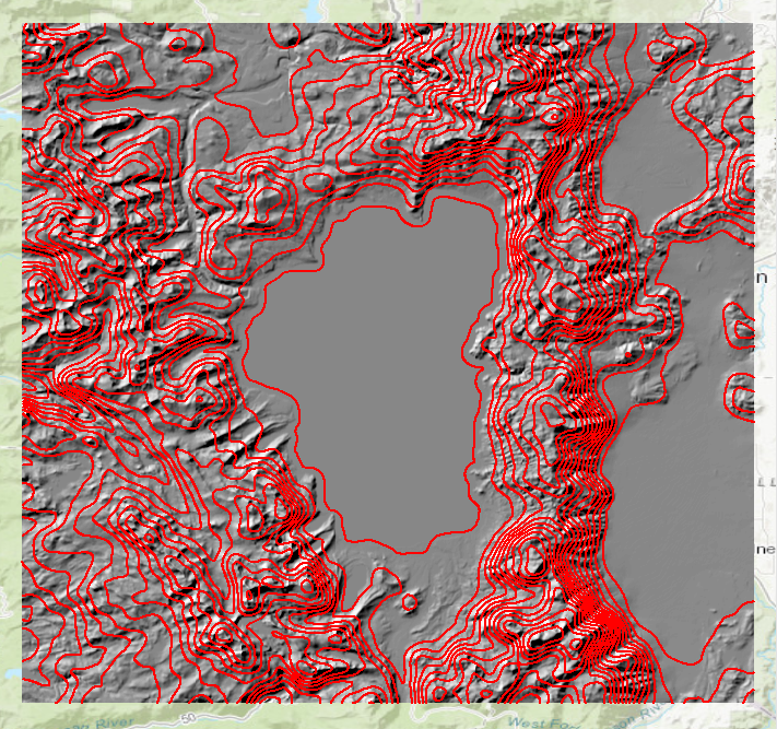
The image below shows a DEM layer and the contour polylines of Lake Tahoe, at the California-Nevada border. Polygons are created from the contour polylines using the Feature To Polygon tool.
Procedure
Follow the steps below to create polygons from contour polylines in ArcMap using the Feature To Polygon tool:
Note:
This tool is available with the Advanced license.
- In ArcMap, enclose the contour polylines.
- Create a new feature class by following the steps outlined in ArcMap: Create a feature class in a database in ArcMap. In this example, a new line feature class is created.
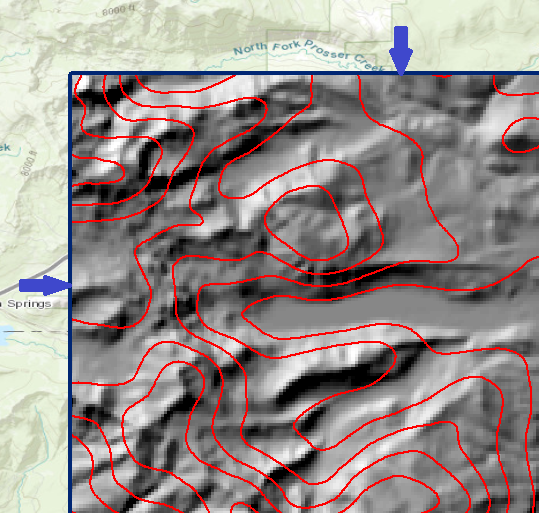
- Start an edit session and draw lines outlining the study boundary.
The image below shows the study boundary is created from a line feature class.
Note:
The Feature To Polygon tool only creates polygons from fully enclosed polylines. Create a new feature class of the study boundary or trace the boundary lines to close the lines manually. For more information on finding closed polylines, refer to ArcMap: Finding polylines or paths that close on themselves.
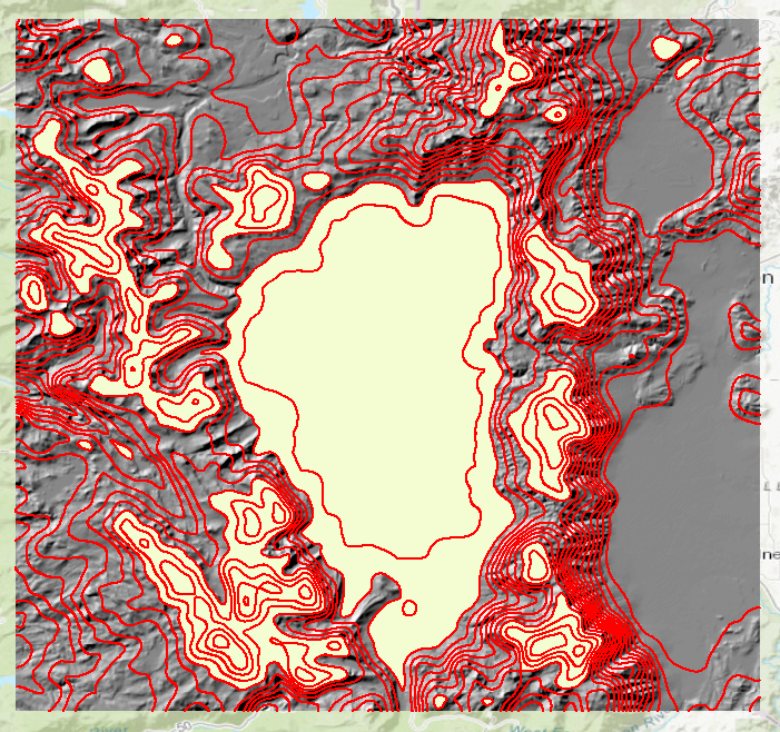
The image below shows polygons are only created for enclosed contour polylines.
- Click the Search icon
 . Search for the Feature To Polygon (Data Management) tool.
 - Click the tool and configure the parameters in the Feature To Polygon dialog box.
Note:
Since the output polygon has limited attributes returned in the attribute table (OBJECTID, SHAPE, SHAPE_Length, and SHAPE_Area), it is not possible to symbolize the polygons based on ascending or descending heights or contour values. So, it is not intuitive in terms of viewing and visualizing high and low areas. For easier interpretation of contour intervals, create filled polygons using the Filled Contours tool which converts DEM to polygon directly. For more information, refer to How To: Create contour polygons from a DEM using the Filled Contours tool.

Other alternatives of converting closed polylines to polygon are:

• Use the Convert Polylines To Polygon function, available with the Production Mapping extension. Refer to ArcMap: Creating polygons from polylines for more information.
• Use the MGCP LandCover Create Polygons function, available with the Defense Mapping extension. Refer to ArcMap: Converting closed polylines to polygons and ArcMap: MGCP LandCover features for more information.
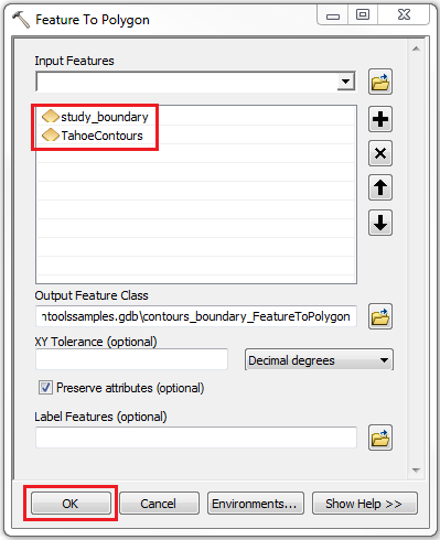
- Select the contour polyline and the study boundary polyline in Input Features. In this example, TahoeContours and study_boundary.
- Click OK.
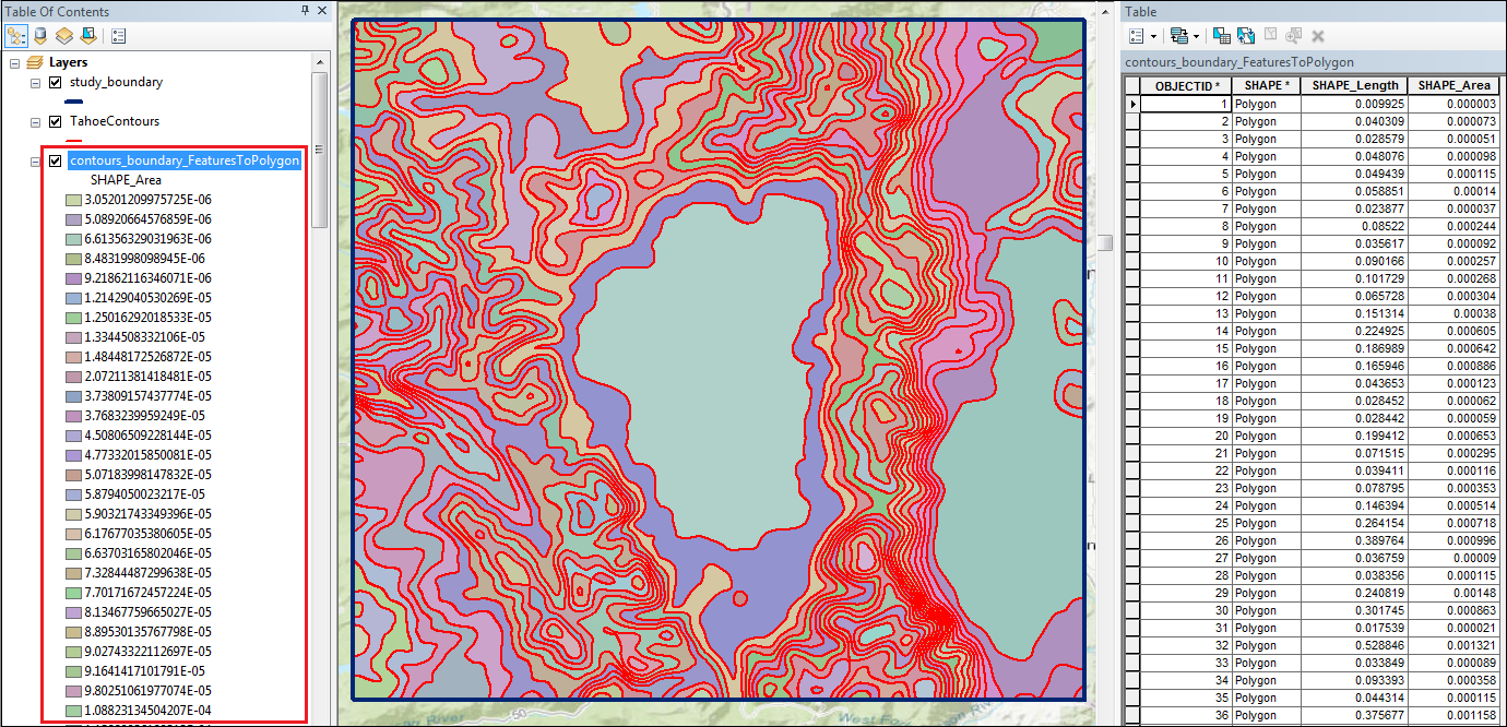
The image below shows a polygon layer is created from the contour and study boundary polyline layers using the Feature To Polygon tool. The polygon layer is symbolized using the Unique Values symbology based on the SHAPE_Area attribute to ease the visualization between each contour interval. The total area of each contour interval is available in the attribute table and easily determined by using the Identify tool.
Article ID: 000012180
- ArcMap
Get support with AI
Resolve your issue quickly with the Esri Support AI Chatbot.


Related Information
Discover more on this topic
Search for related information
Find training related to this topic
Explore ideas and give feedback
Get help from ArcGIS experts
Start chatting now