HOW TO
Set up one-way replicas to send changes from many source geodatabases to a single target geodatabase
Summary
Instructions provided describe how to set up a one-way replication scenario, where edits are being synchronized in one direction from many source geodatabases into one target geodatabase.
Note:
This article pertains to ArcGIS versions 9.x only. Later versions of ArcGIS may contain different functionality, as well as different names and locations for menus, commands and geoprocessing tools.
Procedure
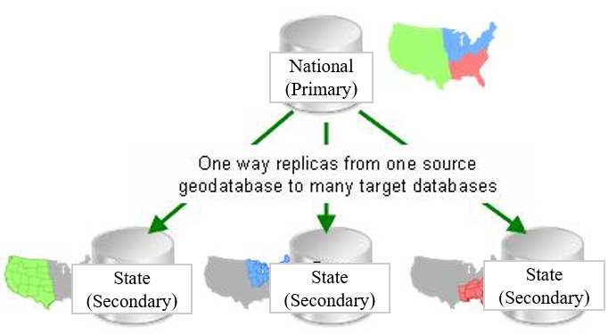
One common use case for one-way replication involves a central geodatabase replicating a subset of data to multiple geodatabases. Referring to the graphic below, imagine a land cover dataset that contains information for the entire United States is stored and maintained in a national geodatabase. Each state is interested in receiving updates only for those features within their state's boundaries. To achieve this, one-way replicas are created from the national geodatabase to each state geodatabase. In this configuration the national geodatabase is assigned the role of primary and the state geodatabases are assigned the role of secondary in each replica pair.
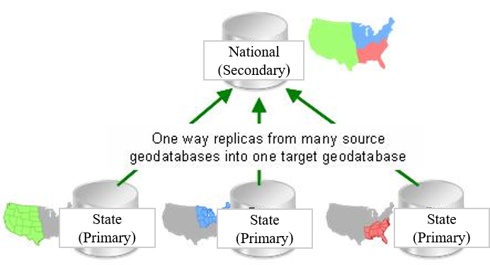
However, there is also a use case for flipping this relationship so each state is responsible for maintaining its own portion of a dataset. Again, referring to the graphic below, instead of updates being sent from the national geodatabase to each state, each state manages its own land cover information and periodically sends updates to the national geodatabase. The edits from each state are synchronized into one comprehensive land cover dataset in the national geodatabase. In this configuration, the national geodatabase is assigned the role of secondary, and the state geodatabases are assigned the role of primary in each replica pair.
This is a valid workflow, but it requires extra steps for correct set up.
Steps for ArcGIS 9.2
- Gather all the data to be included in the replicas into the single secondary geodatabase. The data may already exist on the secondary geodatabase, or it may require loading data from each of the different primary geodatabases into the secondary geodatabase.
- Add Global IDs to the data on the secondary geodatabase. If there is already a Global ID field, skip this step. For more information on Global IDs, refer to ArcMap: ArcGIS field data types.
- Version the data in the secondary geodatabase. For information on versioning, refer to ArcMap: Register and unregister data as versioned.
- If the data exists on the primary geodatabases, delete it. This is an important step because the Global ID values for each feature need to be consistent between the secondary geodatabase and primary geodatabases.
Note:
To minimize downtime for data access at the primary level, instead of deleting the data right away, simply use a second primary geodatabase to perform the remaining steps. Allow read only access to the original data at this time, but do not allow editors to edit the geodatabase as any edits performed on it will be lost. When the replica creation procedures have been completed, swap it out for the new replica geodatabase.
- The next step is to extract the appropriate data to each primary geodatabase. Use the Data Extraction wizard to extract the data to include in the replica to each primary geodatabase.
Note:
Data extraction preserves Global ID values. Replication uses Global IDs to identify the same feature/record across databases, so the values must be consistent across the geodatabases.
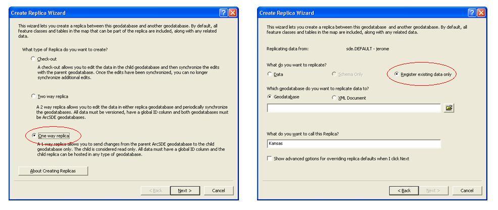
- For each primary geodatabase, create a one-way replica, where the primary geodatabase is the source and the secondary geodatabase is the target, using the Register Existing Data Only option.
Steps for ArcGIS 9.3 or above
For ArcGIS 9.3 or above, use the steps outlined in this section for preparing geodatabases for replication. These steps use new workflows supported at ArcGIS 9.3 that preserve Global ID values when copying and loading data. These steps simplify the procedures required to prepare geodatabases while ensuring that the Global ID values are consistent between geodatabases. Replication uses Global IDs to identify the same feature/record across databases, so the values must be consistent across the geodatabases.
- If all the data to be replicated already exists in the secondary geodatabase, follow the steps outlined in the Steps for ArcGIS 9.2 section above, independent of the ArcGIS release.
- Add Global IDs to the data on the each primary geodatabase. If there is already a Global ID field, skip this step. For more information on Global IDs, refer to ArcMap: ArcGIS field data types.
- Gather all the data from the each of the different primary geodatabases into the secondary geodatabase, making sure to preserve the Global ID values.
- The data now exists in both the secondary geodatabase and primary geodatabases and the Global ID values are consistent between the geodatabases. For each primary geodatabase, create a one-way replica where the primary geodatabase is the source and the secondary geodatabase is the target using the Register Existing Data Only option.
Article ID:000009782
- ArcMap 9 x
Get help from ArcGIS experts
Download the Esri Support App
Related Information
Discover more on this topic
Search for related information
Find training related to this topic
Explore ideas and give feedback