HOW TO
Make the FeatureID (FID) field available to Spatial Analyst tools that take Features as input
Summary
Instructions provided describe how to make the FeatureID (FID) field available to Spatial Analyst tools that take Features as input. FID is not normally available as a field when using a feature class as input to a Spatial Analyst tool.
To use the FID, a new field can be added to the feature class and the FID values transcribed to it.
Procedure
Below is a general procedure to make FID available to Spatial Analyst tools. Some details may vary depending on the nature of the input data.This procedure modifies the attribute table of the feature class. It is highly recommended to work on a copy of the data, to revert to the original, untouched data if necessary.
- Open the Attribute table of the feature class.
- Click the Options button and click 'Add field'.
- Give the new field a name, for example: 'fid2'. It should be of either the Short Integer or Long Integer type.
Note:
Long integer is necessary if the value range is outside of -32,768 to 32,768. - Right-click in the column heading of the new field and select Field Calculator.
Note:
A warning message appears about performing edits outside of an Edit Session, and that changes cannot be undone. Since this procedure should be done on a copy of the data instead of the original, click Yes in the dialog box. - The Field Calculator dialog box appears.
By default, the calculator expression is the new field name obtaining its value from the FID. If not, double-click on the FID entry in the Fields portion of the Field Calculator dialog box.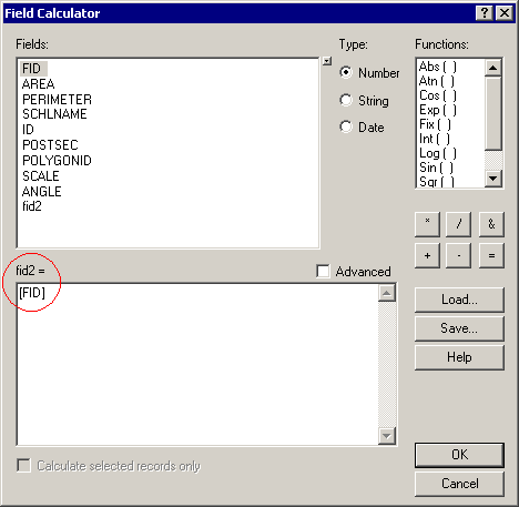
When OK is clicked, the new field is populated with the FID values.
Article ID:000008492
Software:
- ArcMap 9 x
Get help from ArcGIS experts
Download the Esri Support App
Discover more on this topic
Search for related information
Find training related to this topic
Explore ideas and give feedback