[cartography]
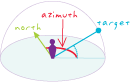
The horizontal angle, measured in degrees, between a baseline drawn from a center point and another line drawn from the same point. Typically, the baseline points true north, and the angle is measured clockwise from the baseline.
[analysis/geoprocessing]
A compass direction. For example, in some GIS software, the direction from which a light source illuminates a surface is called the azimuth. Azimuth is measured from north in clockwise degrees, from 0 to 359.9.
[navigation]
In navigation, the horizontal angle, measured in degrees, between a reference line drawn from a point and another line drawn from the same point to a point on the celestial sphere. Normally, the reference line points true north, and the angle is measured clockwise from the reference line.