PROBLEM
Basemap layers are no longer visible after zooming into the map using ArcGIS Field Maps
Description
In previous releases of the ArcGIS Field Maps mobile app, basemap layers remained visible after zooming in beyond the maximum visible scale ranges set for those layers within the web map or basemap services. In ArcGIS Field Maps 21.4.0 and later, basemap layers are no longer visible after zooming beyond these scale ranges.
Cause
With the 21.4.0 release of Field Maps, this behavior was changed to honor the basemap layer scale properties. This allows control over how basemap layers are rendered in Field Maps.
Solution or Workaround
To make basemap layers stay visible while zooming in on the map in Field Maps, complete the following steps:
- Sign in to the ArcGIS Assistant web app: https://assistant.esri-ps.com/
- Select the web map to modify.
- Choose View Item JSON from the Item Details panel.
- Select the Data tab at the top.
- Choose Edit JSON.
- Locate the section called baseMap.
- Within baseMap, locate the section called baseMapLayers.
- For the basemap layer(s) to remain visible when zooming in on the map in Field Maps, add the following property:
"maxScale": 0
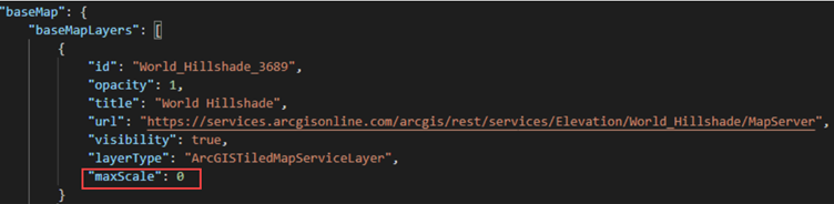
The code section and image below show an example of a basemap layer’s JSON containing the added property:
"baseMap": {
    "baseMapLayers": [
    {
        "id: "World_Hillshade_3689",
        "opacity": 1,
        "title": "World Hillshade",
        "url": "https://services.arcgisonline.com/arcgis/rest/services/Elevation/World_Hillshade/MapServer",
        "visibility": true,
        "layerType": "ArcGISTiledMapServiceLayer",
        "maxScale": 0
    }
- Save the changes.
Article ID: 000027738
- ArcGIS Field Maps Android
- ArcGIS Field Maps iOS
Get support with AI
Resolve your issue quickly with the Esri Support AI Chatbot.


Discover more on this topic
Search for related information
Find training related to this topic
Explore ideas and give feedback
Get help from ArcGIS experts
Start chatting now