HOW TO
Calculate the area of a polygon while excluding the overlapping part of a buffer feature in ArcGIS Pro
Summary
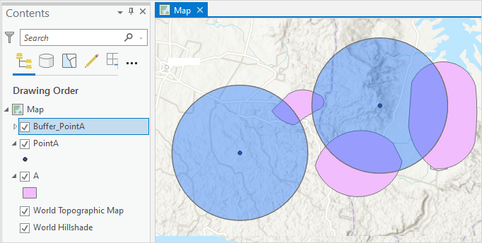
When creating a buffer, the buffer feature layer may overlap a polygon feature layer in ArcGIS Pro. Sometimes it is necessary to calculate the area of the polygon and exclude the overlapping part of the buffer layer to perform another new spatial analysis specifically for that area only.
In the example for this article, calculations are made to determine the area of the polygon, 'A', while excluding the overlapping part with the buffer feature layer in ArcGIS Pro.
Procedure
- Open the ArcGIS Pro project.
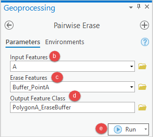
- Use the Pairwise Erase tool to erase the overlapping buffer feature layer from the polygon feature layer.
- In the Geoprocessing pane, search for and click the Pairwise Erase tool. Refer to ArcGIS Pro: Run a tool in the Geoprocessing pane for instructions.
- In the Pairwise Erase pane, under the Parameters tab, select the polygon feature layer from the Input Features drop-down list.
- In the Erase Features drop-down list, select the buffer feature layer.
- Provide a name for Output Feature Class, and click Browse…
 to specify the location for the output feature class.
 - Click Run.
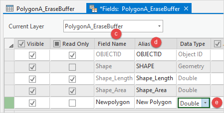
- Add a new field to the attribute table of the new feature class.
- In the Contents pane, right-click the feature layer and click Attribute Table.
- In the attribute table, click Add Field
 . The Fields view opens.
 - In the Fields view, specify a name for the field in the Field Name column.
- Double-click the Alias column of the new field and specify an alias for it.
- Double-click the Data Type column of the new field and select Double from the drop-down menu.
- On the top ribbon, on the Fields tab, click Save.
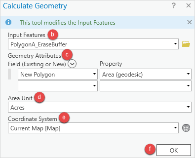
- Populate the spatial information for the field using the Calculate Geometry tool.
- Right-click the field header and select Calculate Geometry to open the Calculate Geometry window.
- In the Calculate Geometry window, select the new feature layer created in Step 2 from the Input Features drop-down list.
- Under Geometry Attributes, select the field for Field (Existing or New), and set Property to Area (geodesic).
- Select the unit of measurement for Area Unit. In this example, Acres is selected.
- Select Current Map [Map] from the Coordinate System drop-down list.
- Click OK.
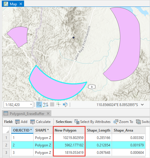
The image below shows the New Polygon field in the table, indicating the area of the polygon that excludes the overlapping part of the buffer feature layer.
Article ID: 000027533
- ArcGIS Pro 2 8 x
- ArcGIS Pro 2 7 x
- ArcGIS Pro 2 x
Get support with AI
Resolve your issue quickly with the Esri Support AI Chatbot.


Related Information
Discover more on this topic
Search for related information
Find training related to this topic
Explore ideas and give feedback
Get help from ArcGIS experts
Start chatting now