Frequently asked question
Is there a geoprocessing tool to transform the vertical datum of raster elevation values in ArcMap and ArcGIS Pro?
A workaround to transform the vertical datum of elevation raster values is to convert the raster dataset to point features, and then define the desired vertical coordinate system before converting the point features back to a raster dataset. The following steps describe how to vertically transform the values in an elevation raster in ArcMap or ArcGIS Pro:
Note:
To enable the transformation, ensure ArcGIS Coordinate System Data is installed for ArcMap or ArcGIS Pro. Additionally, some tools in this workaround require the Advanced license level: 3D Analyst, and Spatial Analyst extensions.
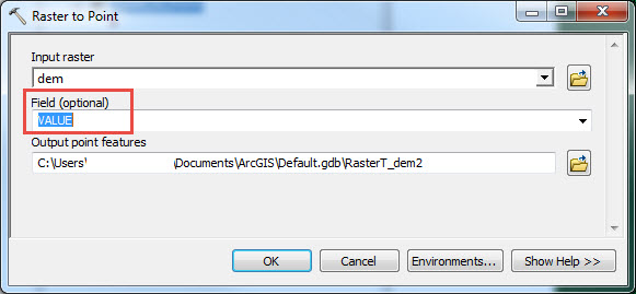
- Run the Raster to Point (Conversion) tool on the elevation raster and define the following parameters:
- For Input raster, select the desired raster to convert.
- For Field, select VALUE.
- For Output point features, select the output feature class to store the points.
Note:
The output of the VALUE field from each cell is an attribute of each corresponding point in the GRID_CODE field.
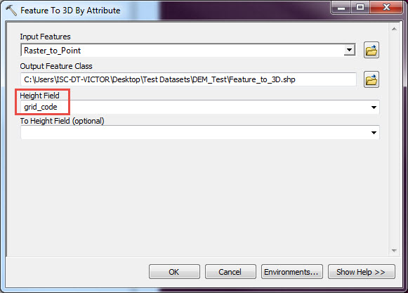
- Run the Feature to 3D by Attribute (3D Analyst) tool and define the following parameters:
- For Input Features, select the feature created in Step 1.
- For Output Feature Class, choose the output location.
- For Height Field, select grid_code.
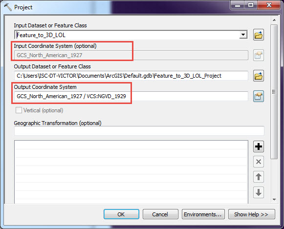
- Run the Project (Data Management) tool to determine if the vertical coordinate system of the 3D-enabled points created in Step 2 is defined. If the VCS (Z-coordinate) is not defined and appears as 'Unknown VCS' or is missing in the Input Coordinate System field, proceed with the following sub-steps. If the VCS is defined for the input dataset, proceed to Step 4.
- For Input Dataset or Feature Class, select the dataset created in Step 2.
- For Input Coordinate System, define both the XY and Z coordinates used by the original raster.
- For Output Dataset or Feature Class, select the desired feature class as the output location.
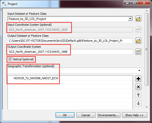
- Run the Project (Data Management) tool and specify the new vertical coordinate system. Ensure the Vertical box is checked.
- For Input Dataset or Feature Class, select the dataset created in Step 1.
- For Output Dataset or Feature Class, select the desired feature class as the output location.
- For Output Coordinate System, define the new XY and Z coordinates.
- Check the Vertical check box. Checking Vertical automatically populates the Geographic Transformation parameter.
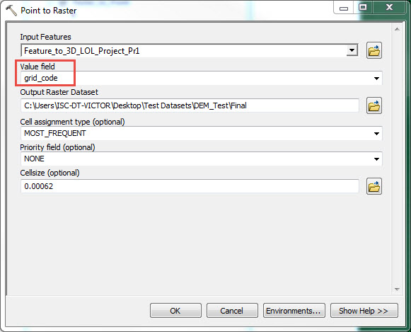
- Run the Point to Raster (Conversion) tool. The output raster contains the values that have been adjusted according to a vertical transformation.
Article ID: 000016918
Software:
- ArcMap
- ArcGIS Pro
Get support with AI
Resolve your issue quickly with the Esri Support AI Chatbot.


Related Information
Discover more on this topic
Search for related information
Find training related to this topic
Explore ideas and give feedback
Get help from ArcGIS experts
Start chatting now