PROBLEM
The NDVI function on the Image Analysis window returns unexpected results
Description
The Normalized Difference Vegetation Index (NDVI) function on the Image Analysis window generates a standardized index representing relative biomass health and density. In some instances, applying the NDVI function to remotely sensed satellite imagery returns unexpected results.
Cause
The NDVI function requires the correct input of the red and near infrared bands, since it calculates the differential reflection of the bands. Band orders corresponding to the red and infrared differ depending on the specific satellite sensor or source data. Selecting incorrect band orders for the red and near infrared bands returns incorrect results.
Solution or Workaround
Specify the correct band orders for the red and near infrared inputs in the Image Analysis window.
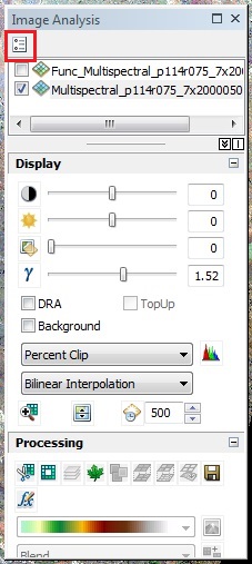
- In ArcMap, navigate to Windows > Image Analysis.
- Click the Options button on the Image Analysis dialog box.
- On the NDVI tab, verify the inputs for the Red Band and Infrared Band are in the correct order. For example, in Landsat 8 imagery, the input for the Red Band is band 4 and the input for the Near Infrared Band is band 5.
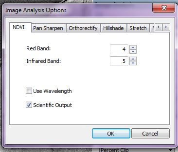
For band order information for other satellite sensor raster types, refer to the following documentation, ArcGIS Help: Satellite sensor raster types.
Note:
 The Infrared Band field requires an input of the near infrared band order.
Note:
Alternatively, check the check box next to Use Wavelength to use the wavelength information present in the dataset.
Note:
 Check the check box next to Scientific Output to produce outputs in the range of -1.0 to 1.0. By default, ArcMap outputs NDVI values in the range of 0 to 200 for a better color ramp rendition. For more information on the significance of the output values, refer to the following documentation, ArcGIS Help: NDVI function.
- Click OK.
- Select the layer to be analyzed in the Image Analysis window.
- Click the NDVI icon under the Processing section.
![[O-Image]](https://webapps-cdn.esri.com/CDN/support-site/technical-articles-images/000012443/00N39000003LL2C-0EM39000000wdd7.png)
Note:
 The output of the Image Analysis window is added to the map document as a temporary layer.  To save the output layer as a raster dataset, click the Export button on the Image Analysis window and specify the output location of the raster dataset.
![[O-Image]](https://webapps-cdn.esri.com/CDN/support-site/technical-articles-images/000012443/00N39000003LL2C-0EM39000000wdd3.png)
Article ID: 000012443
- ArcMap
Get support with AI
Resolve your issue quickly with the Esri Support AI Chatbot.


Related Information
Discover more on this topic
Search for related information
Find training related to this topic
Explore ideas and give feedback
Get help from ArcGIS experts
Start chatting now