PROBLEM
Searching an address using ArcGIS World Geocoding service returns the correct geographic location with a different city name
Description
ArcGIS World Geocoding service enables finding addresses, businesses, and places around the world. Almost any address can be used to search for a location and the geocoding service returns the best match for the address searched. However, sometimes it may seem that the search does not return the expected results. For example, when searching for "8600 NW 17th St, Doral, FL", the search returns the correct geographic location but with a different (city) address "8600 NW 17th St, Miami, Florida, 33126".
Cause
The ArcGIS World Geocoding services has some default properties that are used to search for an address. By default, all results returned by the World Geocoding Service return the Postal city name. In this case, the 33126 postal code includes parts of Miami and Doral, FL.
Solution or Workaround
Some of these properties can be manually modified in a search request. You can overwrite this by passing in the preferredLabelValues parameter to the REST API and including either localCity or matchedCity as the value. See the following document for more information: ArcGIS REST APIs: geocodeAddresses
Note:
The Enterprise 11 documentation includes information that the preferredLabelValues parameter was new at version 10.8 for the reverseGeocode and suggest topics, but the latest versions of those topics do not state that.
| Parameter Value | Description |
| postalCity | Include the primary postal city value in geocoding response output fields, even if it is different than the city name in the geocoding request. This is the primary name assigned to the postal code of the address. |
| localCity | Include the primary local city name in geocoding response output fields, even if it is different than the city name in the geocoding request. This is the name of the city that the address is actually within, and may be different than the postal city. |
| matchedCity | If the input city name in a geocoding request matches any of the local city or postal city names associated with an address, include the matched value in geocoding response output fields. If a city name is not included in the input, or is included but doesn't match to anything, then default address formats will be used. |
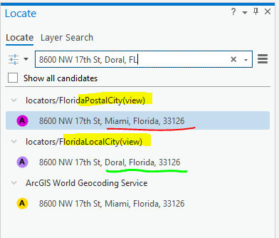
Below is an illustration of the different locator view results with different preferred city name settings. The postalCity parameter returns a Miami location, while localCity returns the adjoining city of Doral.
You can also create a Locator View of the World Geocoding Service and adjust the setting there. The organization's administrator can then replace the current World Geocoding Utility service with the locator view option so the whole organization can see results with this option enabled by default. For more information, see: ArcGIS Online: Create a locator view
The information regarding the preferredLabelValues also applies to locators created with the Create Locator tool and the new StreetMap Premium locators that are published as services to ArcGIS Enterprise 10.8 and later.
Unfortunately, the ability to include the preferredLabelValues parameter when using the REST endpoint form is not available in releases before ArcGIS Enterprise 11. In those prior versions, it is necessary to include that parameter in geocoding operation requests, such as findAddressCandidates, reverseGeocode, suggest, and geocodeAddresses.
Article ID: 000027326
- ArcGIS Server
- ArcGIS Pro 3 0
- ArcGIS Pro 2 8 x
- ArcGIS Pro 2 7 x
- ArcGIS Pro 2 x
Get support with AI
Resolve your issue quickly with the Esri Support AI Chatbot.


Related Information
Discover more on this topic
Search for related information
Find training related to this topic
Explore ideas and give feedback
Get help from ArcGIS experts
Start chatting now