BUG
The Rotate Tool does not work properly during the georeference workflow.
Description
When a computer's regional settings use something other than a period (.) as a decimal separator, the georeference rotation tool fails to save the rotation set by the user when there is not an associated spatial reference for the data.
Cause
This is caused by a decimal symbol set as something other than a period, and/or the digit grouping symbol set as something other than a comma (,).
Workaround
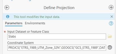
To workaround this issue, define a projection for your BIM or CAD features before adding your BIM or CAD content to a map.
- Run the Define Projection geoprocessing tool on the BIM File feature class (IFC or Revit).
- Once the projection is defined, add your content to a map or scene and continue with the georeferencing process.
- This issue has been resolved in ArcGIS Pro 2.9.
- This issue does not affect ArcGIS Pro 2.7.3 and earlier versions.
Article ID: 000026101
- ArcGIS Pro 2 8 x
Get support with AI
Resolve your issue quickly with the Esri Support AI Chatbot.


Discover more on this topic
Search for related information
Find training related to this topic
Explore ideas and give feedback
Get help from ArcGIS experts
Start chatting now