PROBLEM
Zipped shapefiles and CSVs published to ArcGIS Online offset from services published from ArcMap
Description
Zipped shapefiles and CSV files published to ArcGIS Online appear offset from the same features published via ArcMap, when viewing in the ArcGIS Online map viewer.
Cause
This issue occurs due to the measurement and coordinate system used in the shapefiles as ArcGIS Online only uses the WGS 1984 Web Mercator (Auxiliary Sphere) coordinate system. The geographic transformation process is only applied during the publishing phase. Hence, when publishing a layer with a different projection, the layers appear offset from the layers published via ArcMap when viewing it in the ArcGIS Online map viewer. The ArcGIS Online map viewer does not support geographic transformations.
Solution or Workaround
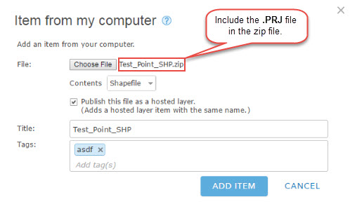
The following are some pointers to ensure zipped shapefiles, and CSV files published in both ArcMap and ArcGIS Online do not appear offset when viewed in the ArcGIS Online map viewer.- For zipped shapefiles
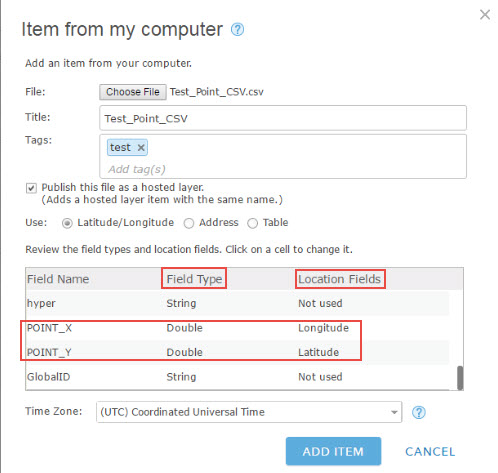
- For CSV files
- Publishing from ArcMap
Note:
When a CSV file containing latitude and longitude information is added to a map, the latitude, longitude coordinates are converted to the spatial reference of the current basemap. Hence, users may also publish the layers from ArcMap using any coordinate system, and must ensure the basemap in the map viewer matches the same coordinate system.
Article ID: 000014301
- ArcGIS Online
Get support with AI
Resolve your issue quickly with the Esri Support AI Chatbot.


Related Information
Discover more on this topic
Search for related information
Find training related to this topic
Explore ideas and give feedback
Get help from ArcGIS experts
Start chatting now