PROBLEM
Using a CSV file in the XY Table To Point tool returns a warning message in ArcGIS Pro
Description
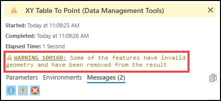
In ArcGIS Pro, the XY Table To Point tool allows creating a point feature class from the coordinate data in the table of a CSV file. In certain cases, generating a point feature class using a CSV file in the XY Table To Point tool fails, and returns the following warning message:
Warning:
100160: Some of the features have invalid geometry and have been removed from the result
Cause
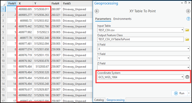
The X and Y field values are less than -400 or greater than 400 when used with a geographic coordinate system in the XY Table To Point tool. Refer to ArcGIS Pro: Usage for more information.
Solution or Workaround
Use one of the following options to generate a point feature class using a CSV file in the XY Table To Point tool:
Note:
Coordinate values with the N, S, E, and W abbreviations in the CSV file are imported as text values in ArcGIS Pro, and cannot be used as input coordinates in the XY Table To Point tool. Refer to ArcGIS Pro: Format a table in Microsoft Excel for use in ArcGIS Pro for more information.
Note:
Refer to ArcGIS Pro: Coordinate systems for more information regarding the units used for different types of coordinate systems.
Use coordinate values between -400 and 400 when selecting a geographic coordinate system in the XY Table To Point tool
In ArcGIS Pro, use a CSV file containing coordinate values between -400 and 400 in decimal degrees when selecting a geographic coordinate system in the XY Table To Point tool.
Note:
Coordinate values containing spaces, such as the Degrees Decimal Minutes (DDM) or Degrees Minutes Seconds (DMS) format, are regarded as Null values when used in the XY Table To Point tool.
Use a projected coordinate system in the XY Table To Point tool
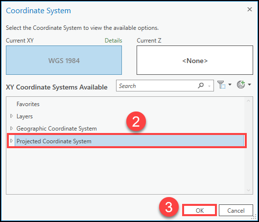
In ArcGIS Pro, use a projected coordinate system in the XY Table To Point tool if the coordinate values are less than -400 or more than 400, and are in linear units. Use the following steps to select a projected coordinate system in the XY Table To Point tool:
- In ArcGIS Pro, click the Select coordinate system
 icon in the XY Table To Point geoprocessing pane.
 - In the Coordinate System dialog box, double-click Projected Coordinate System in the XY Coordinate Systems Available list, and select a suitable projected coordinate system.
- Click OK.
Article ID: 000027430
- ArcGIS Pro 2 8 x
- ArcGIS Pro 2 x
Get support with AI
Resolve your issue quickly with the Esri Support AI Chatbot.


Related Information
Discover more on this topic
Search for related information
Find training related to this topic
Explore ideas and give feedback
Get help from ArcGIS experts
Start chatting now