PROBLEM
True curve features are densified in Map Viewer
Description
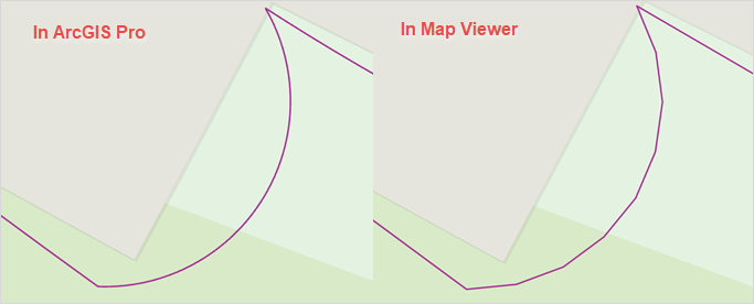
When a feature layer containing true curves is published from ArcGIS Pro to the ArcGIS Enterprise portal or ArcGIS Online, the curved geometry is automatically densified into polylines in Map Viewer. This densification replaces the original curved geometry with straight-line segments and results in jagged lines, particularly when viewed at large scales.
Cause
This is expected behavior when publishing true curve geometries from ArcGIS Pro. Although hosted feature layers in the ArcGIS Enterprise portal and ArcGIS Online can store true curve features, they do not fully support rendering curved geometries. As a result, the curves are densified into straight segments for display in Map Viewer and other web apps.
Solution or Workaround
Densify curves before publishing from ArcGIS Pro using the Densify tool
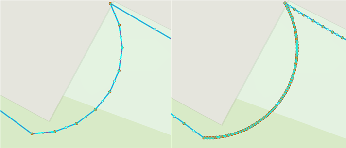
Before publishing, use the Densify tool in ArcGIS Pro to convert the true curves into segmented polylines by adding vertices at specified distance intervals. Adjusting the distance parameter and vertex density preserves the original curve geometry and prevents jagged or angular lines in Map Viewer.
- Open the ArcGIS Pro project.
- Use the Densify tool to add vertices along the curves. For instructions to find and use the geoprocessing tool, refer to ArcGIS Pro: Find a geoprocessing tool.
- In the Densify pane, for Input Features, select the feature layer.
- For Densification Method, select Distance.
- For Distance, specify a value and the appropriate unit.
- Click Run.
- Publish the feature layer to the ArcGIS Enterprise portal or ArcGIS Online. Refer to ArcGIS Pro: Share a web feature layer using the default configuration for instructions.
The image below shows the improved visual representation of the curve features after using the Densify tool to increase vertex density, preserving the intended shape in Map Viewer.
Publish the feature layer containing true curves as a map image layer
To preserve true curve geometry in Map Viewer, publish the feature layer as a map image layer. Map image layers maintain curved geometries and render them accurately without converting the curves into straight line segments. Refer to ArcGIS Pro: Share a map image layer using the default configuration for instructions.
Article ID: 000037389
- ArcGIS Pro
- ArcGIS Online
- Portal for ArcGIS
- ArcGIS Enterprise
Get support with AI
Resolve your issue quickly with the Esri Support AI Chatbot.


Related Information
Discover more on this topic
Search for related information
Find training related to this topic
Explore ideas and give feedback
Get help from ArcGIS experts
Start chatting now