PROBLEM
The LAS Dataset To Raster tool fails to execute when the input is in a geographic coordinate system
Description
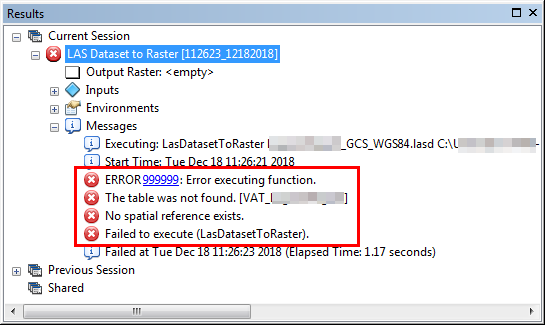
When running the LAS Dataset To Raster tool in ArcMap with a LAS dataset in a geographic coordinate system as the input, the tool runs for a long time and does not return any output. In some instances, the tool crashes or returns one of the following error messages:
Error:
ERROR 999999: Error executing function.
The table was not found. <Lidar data>
No spatial reference exists.
Failed to execute (LasDatasetToRaster).
Error:
000210: Cannot create output.
Cause
This is a known limitation. Refer to BUG-000098091 for more information.
Solution or Workaround
Use the LAS To LAS tool
Download the 3D Sample Tools, and use the LAS To LAS tool to project the LAS dataset to a projected coordinate system.
Note:
The 3D Samples Toolbox is for ArcGIS Desktop 10.2 to 10.6. Later versions of ArcGIS may contain different functionality, as well as different names and locations for menus, commands and geoprocessing tools. The toolbox depends on the ArcMap version. For later versions of ArcGIS Desktop, see the Use the Extract LAS tool solution below.
- Download the 3D Sample Tools from the following link: 3D Sample Tools.
- In ArcMap, add the 3D Sample Tools (.tbx) in ArcToolbox. For steps to do this, refer to Key features of the ArcToolbox window.
- Run the LAS To LAS tool to project the LAS dataset to a projected coordinate system.
- In ArcToolbox, navigate to 3D Sample Tools > Lidar Management > LAS To LAS.
- In the LAS To LAS dialog box, select the LAS dataset for the Input LAS Dataset.
- Set the Target Folder.
- In the Spatial Reference Action drop-down list, select Project.
- For the New Coordinate System, select a projected coordinate system for the LAS dataset.
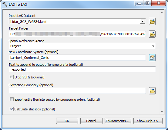
- Click OK. The output projected LAS files are located in the target folder.
- Create a new LAS dataset using the projected LAS files. For steps to do this, refer to Create a LAS Dataset using the geoprocessing tool. Select the projected LAS files for the Input Files.
- Use the output LAS dataset from Step 4 as an input for the LAS Dataset To Raster tool to create a raster.
Use the Extract LAS tool to project the LAS dataset to a projected coordinate system.
- In ArcToolbox, navigate to 3D Analyst Tools > Data Management > LAS Dataset > Extract LAS.
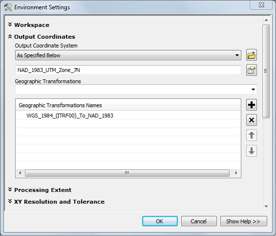
- Extract and project the LAS dataset through the Output Coordinate System environment setting.
- In the Extract LAS window, select the LAS dataset for Input LAS Dataset.
- Set the Target Folder and Output LAS Dataset parameters.
- Click Environments, and expand Output Coordinates.
- Select the Output Coordinate System and Geographic Transformations, and click OK.
- Click OK to run the Extract LAS tool.
- Create a new LAS dataset using the projected LAS files.
- Use the output LAS dataset from Step 3 as an input for the LAS Dataset To Raster tool to create a raster.
Article ID: 000019633
- ArcMap
Get support with AI
Resolve your issue quickly with the Esri Support AI Chatbot.


Related Information
Discover more on this topic
Search for related information
Find training related to this topic
Explore ideas and give feedback
Get help from ArcGIS experts
Start chatting now