PROBLEM
The Classification Wizard tool is disabled in ArcGIS Pro
Description
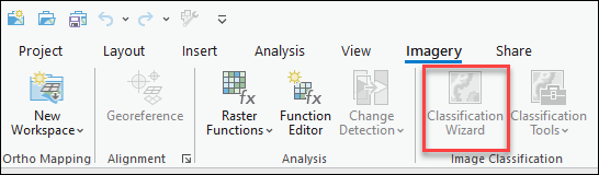
The Classification Wizard tool is used to classify satellite images and aerial imagery into land use and land cover categories. However in some instances, the Classification Wizard tool is disabled, as shown in the image below.
Cause
- The Image Analyst or Spatial Analyst license is not assigned to the members.
- Non-raster data are selected.
Solution or Workaround
Based on the cause, the following workarounds to enable the Classification Wizard tool are applicable.
Assign the Spatial Analyst or Image Analyst license to the member
Administrators or members of an organization with license management privileges must assign the Spatial Analyst or Image Analyst license to the member in ArcGIS Online.
- Log in to ArcGIS Online using the organizational account.
- Click the Organization tab > Licenses > Add-on licenses.
- Navigate to the ArcGIS Pro extensions section, and click Manage for Spatial Analyst or Image Analyst.
- Toggle the required member’s name on to assign the license.
Note:
Contact Esri Customer Service to purchase the license if the extension license is not included in the organization’s subscription.
Select the raster data to use the Classification Wizard tool
In ArcGIS Pro, select only the raster layer in the Contents pane to enable the Classification Wizard tool.
Article ID: 000028239
- ArcGIS Online
- ArcGIS Pro 3 0
- ArcGIS Pro 2 8 x
- ArcGIS Pro 2 7 x
- ArcGIS Pro 2 x
Get support with AI
Resolve your issue quickly with the Esri Support AI Chatbot.


Related Information
Discover more on this topic
Search for related information
Find training related to this topic
Explore ideas and give feedback
Get help from ArcGIS experts
Start chatting now