PROBLEM
Spatial Analyst tools fail and return error 010005 in ArcGIS Pro
Description
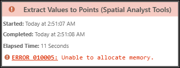
In ArcGIS Pro, when using certain tools from the Spatial Analyst toolbox, such as the Reclassify, Optimal Path As Line, Extract Values to Points, or Extract Multi Values to Points, the tool fails and returns the following error message:
Error:
Error 010005: Unable to allocate memory.
Cause
The local machine does not have sufficient available memory to perform the operation. This often occurs when processing very large datasets as complex computations require more drive space. While this issue can affect both raster and vector data, it is more common with raster data due to their grid-based structure, which typically require more memory during processing.
Additionally, tools that use the geodesic distance method rather than the planar distance method often require more memory and processing power due to the complexity of the calculations. Geodesic methods measure distances along the Earth's curved surface, accounting for its 3D ellipsoidal shape and ensuring greater accuracy over long distances. In contrast, planar distance methods simplify calculations by measuring within a 2D Cartesian coordinate system, which is less resource-intensive but can introduce distortions, especially over larger areas. Although geodesic calculations do not inherently increase data volume, their computational demands can affect processing efficiency. For more information, refer to ArcGIS Pro: Geodesic versus planar distance.
Another cause is if the extent of the point features exceeds the extent of the input raster when using the Extract Values to Points or Extract Multi Values to Points tool.
Solution or Workaround
Note:
To use the tools in the Spatial Analyst toolbox, ensure the ArcGIS Spatial Analyst extension is active. For more information, refer to ArcGIS Pro: Enable the Spatial Analyst extension.
There are several methods to resolve the issue. For more information, refer to ArcGIS Pro: 010005: Unable to allocate memory. Additional applicable workarounds are provided below.
Create a tile using the Create Map Tile Package tool
The Create Map Tile Package tool helps optimize workflows involving large datasets by packaging data into pre-generated tiles. While it does not directly resolve the issue, using tile packages can reduce the memory demand during rendering and improve performance by avoiding dynamic processing of large datasets. Additionally, tile packages require less disk storage compared to storing full datasets, which optimizes storage efficiency.
Use the Clip Raster or Clip tool
Clip specific areas of the data (area of interest) and use the clipped data as the input.
- For raster data, use the Clip Raster tool.
- For vector data, use the Clip or Pairwise Clip tool.
Reduce the resolution of the raster dataset or generalize the features
- For raster data, reduce the resolution to decrease the dataset size. For more information, refer to ArcGIS Pro: Altering the resolution of a raster.
- For vector data, generalize or simplify the line or polygon layers. For instructions, refer to How To: Reduce the number of polygon vertices in ArcGIS Pro
Adjust the extent of the point features
When using tools such as the Extract Values to Points or Extract Multi Values to Point, ensure the extent of the point features is smaller than or within the raster layer.
- Select the features within the raster area and use it as the input data using the selection tools. If necessary, export the selected point features as a new feature class.
- Configure the processing extent of the input layer in the tool parameters or environment. Only certain tools allow processing extent configuration. For details, refer to ArcGIS Pro: Processing extent.
Upgrade to ArcGIS Pro 3.2.2 or later
The issue with the Optimal Path As Line tool is resolved in ArcGIS Pro 3.2.2. To update the software, refer to ArcGIS Pro: Update ArcGIS Pro.
Article ID: 000034205
- ArcGIS Pro 3 3
- ArcGIS Pro 3 2
- ArcGIS Pro 3 4
Get support with AI
Resolve your issue quickly with the Esri Support AI Chatbot.


Related Information
Discover more on this topic
Search for related information
Find training related to this topic
Explore ideas and give feedback
Get help from ArcGIS experts
Start chatting now