PROBLEM
Shapefile features are generalized when added to an ArcGIS Online web map
Description
When a shapefile is added to the ArcGIS Online map viewer from the Add > Add Layer from File menu, the features are not displayed properly. For example, the curves of the original features are not retained after the shapefile is added to the ArcGIS Online map viewer.
Cause
This issue occurs when the ArcGIS Online map viewer transforms the shapefile into a feature collection and generalizes the features of the shapefile when added directly to the ArcGIS Online map viewer. For more information, refer to: ArcGIS Online: Generalize features for web display
Solution or Workaround
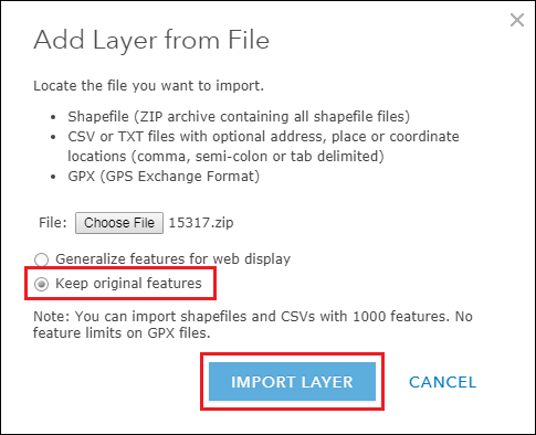
Use one of the following options to solve the issue:Select the Keep original features option when adding the shapefile to the web map
- In the web map, click Add > Add Layer from File.
- Click Choose File, and upload the zipped shapefile to the web map.
- Select Keep original features.
- Click IMPORT LAYER to add the selected shapefile to the web map.
To publish zipped shapefiles to ArcGIS Online from local data in My Content, refer to: ArcGIS Online: Publish a shapefile or GeoJSON file
Publish the shapefile to ArcGIS Online directly from ArcMapTo publish shapefiles from ArcMap to ArcGIS Online, follow the steps in: ArcGIS Online: Publish from ArcMap
The last two options create a hosted feature layer in the My Content page. The published hosted feature layer can be added to the ArcGIS Online web map and displays the features as the original shapefile. Refer to the instructions in Search for layers to add a hosted feature layer to a web map.
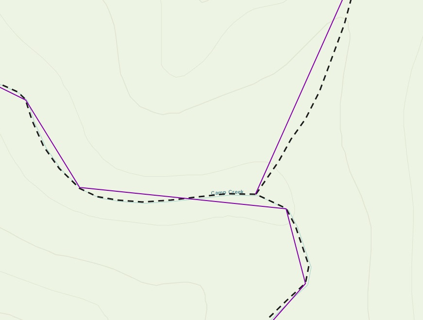
The following figure is an example of the generalized features (solid line) overlaying the original features (dotted line) of a shapefile added to the ArcGIS Online web map:
Note:
In some instances, uploading a zipped shapefile from My Content > From my computer or directly from ArcGIS Desktop results in a blank display when the hosted feature layer is added to a web map. A possible cause of this issue is due to bad geometry contained in the shapefile before it is published as a feature layer. To solve this issue, use the Repair Geometry tool to fix the geometry problems before publishing the shapefile to ArcGIS Online.
Article ID: 000015317
- ArcMap
- ArcGIS Online
Get support with AI
Resolve your issue quickly with the Esri Support AI Chatbot.


Related Information
Discover more on this topic
Search for related information
Find training related to this topic
Explore ideas and give feedback
Get help from ArcGIS experts
Start chatting now