PROBLEM
Raster dataset is sightly shifted after using the Mosaic tool to add new rasters
Description
If raster datasets are loaded into a new, empty raster dataset using the Mosaic geoprocessing tool, the resulting raster dataset may be slightly shifted compared to the source raster. The shift is usually smaller than the cell size of the raster.
Cause
The shift is caused by the choice of the pyramid reference point. When creating a new raster dataset, the value for the pyramid reference point in the Create Raster Dataset tool is automatically filled in by default.
This automatically filled in value varies depending on the coordinate system of the new raster dataset and is not within a reasonable coordinate range. The automatically set pyramid reference point may have a distance that is not a meaningful multiple of the cell size of the raster, so there is a slight shift (< 1 cell size) between the source rasters and the target raster when loading rasters into the raster dataset.
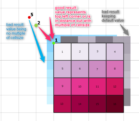
If the pyramid reference point is explicitly set manually, it should ideally represent the top left corner of the target raster dataset, as shown in the image below.
However, the pyramid reference point does not have to be exactly at the top left corner of the final target raster dataset, it can be at a greater distance outside the extent of the target grid, but the distance should always be a multiple of the cell size of the target grid.
Solution or Workaround
When creating a new raster dataset, the automatically set value for the pyramid reference point should not be accepted, but should always be edited manually.
The value for the pyramid reference point should be set in a way, that it either exactly maps the upper left corner of the final target raster, or is clearly outside the target extent in the XY direction. However, the distance must always be a multiple of the raster cell size of the target raster so that the target raster is not shifted.
The automatically filled value can also be deleted and the parameter for the pyramid reference point can then remain empty. However, this is not recommended for performance reasons.
Article ID: 000032816
- ArcGIS Pro
Get support with AI
Resolve your issue quickly with the Esri Support AI Chatbot.


Related Information
Discover more on this topic
Search for related information
Find training related to this topic
Explore ideas and give feedback
Get help from ArcGIS experts
Start chatting now