PROBLEM
Near returns different results than Measure Distance in ArcGIS Pro
Description
In ArcGIS Pro, calculating the distance between two features from different feature layers yield different results depending on whether the Near tool or the Measure Distance tool is used. For example, when measuring the distance between feature A and feature B, the Near tool returns a value of 821,175.436331 meters, as shown in the map image below.

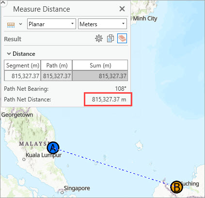
Meanwhile, measuring the distance between feature A and feature B using the Measure Distance tool returns a value of 815,327.37 meters, as shown in the image below.
Cause
The coordinate systems of the layers and the map do not match, causing discrepancies in the distance values. The Near tool calculates distances based on the coordinate system of the input layer, whereas the Measure Distance tool calculates distances based on the coordinate system of the map.
Solution or Workaround
To ensure consistent distance measurements when using either the Near or Measure Distance tool, match the coordinate systems of the layer and map accordingly.
Note:
•  To check the map coordinate system, right-click the map layer in the Contents pane, click Properties, and click the Coordinate System tab.
•  To check the layer coordinate system, right-click the layer in the Contents pane, click Properties, click the Source tab, and expand the Spatial Reference node.
Match the map coordinate system to the layer coordinate system
Change the map coordinate system to match the layer coordinate system. Refer to ArcGIS Pro: Set the coordinate system for instructions.
Match the layer coordinate system to the map coordinate system
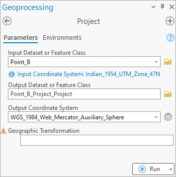
- In the Geoprocessing pane, search for and click Project (Data Management Tools).
- For Input Dataset or Feature Class, select the layer with a coordinate system to be projected. In this example, the Point_B layer with the Indian 1954 UTM Zone 47N coordinate system is selected.
- For Output Dataset or Feature Class, rename the parameter is necessary.
- For Output Coordinate system, select Current Map [Map] from the drop-down list to copy the map coordinate system. This option automatically specifies the map coordinate system. In this example, the map coordinate system is WGS 1984 Web Mercator Auxiliary Sphere.
- Click Run.
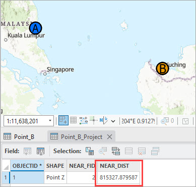
Use the tool's output layer as the input for the Near tool to measure distance. The map image below shows the distance measured using the Near tool when the map and the layer share the same coordinate system. The value is consistent with the distance measured using the Measure Distance tool.
Article ID: 000033399
- ArcGIS Pro 3 1
- ArcGIS Pro 3 3
- ArcGIS Pro 3 2
Get support with AI
Resolve your issue quickly with the Esri Support AI Chatbot.


Related Information
Discover more on this topic
Search for related information
Find training related to this topic
Explore ideas and give feedback
Get help from ArcGIS experts
Start chatting now