PROBLEM
Footprint extents do not match raster images in ArcGIS Pro
Description
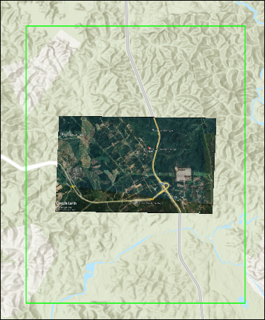
In ArcGIS Pro, footprints in mosaic datasets define the spatial extent of raster images. However, in some cases, the footprints do not accurately align with the actual bounds of the raster images. Instead, they exceed the image true extent, causing display inconsistencies, inaccurate spatial queries, and issues during analysis and data management.
The map below shows the footprint extent exceeding the image true extent.
Cause
This issue occurs when the raster image contains missing pixels or areas with NoData values around the edges. ArcGIS Pro generates footprints based on the full bounding extent of the images, rather than excluding the pixels with NoData values.
Solution or Workaround
Note:
This workflow requires the ArcGIS Pro Standard or Advanced license.
Reduce the distance of the footprint in the mosaic dataset
- Open the ArcGIS Pro project containing the mosaic dataset.
- Reduce the footprint distance in the mosaic dataset using the Build Footprints tool.
Note:
For instructions to find and use the geoprocessing tool, refer to ArcGIS Pro: Find a geoprocessing tool.
- In the Build Footprints pane, for Mosaic Dataset, select the mosaic dataset from the drop-down list.
- For Shrink distance, specify the preferred distance to clip the footprint.
- Click Run.
Remove the image border with NoData values in the mosaic dataset
- Open the ArcGIS Pro project containing the mosaic dataset.
- Remove the border by adjusting the minimum and maximum data values of the mosaic dataset. Refer to How To: Remove black or white borders from a mosaic dataset in ArcGIS Pro for instructions and more information.
Exclude NoData values from the raster dataset
Note:
The Extract by Mask tool requires the Spatial Analyst license.
- Open the ArcGIS Pro project containing the raster dataset.
- Exclude NoData values from the raster image using the Extract by Mask tool before creating a mosaic dataset. Refer to the solution section in Problem: Raster cell values are overridden when combined with NoData values in ArcGIS Pro for instructions.
- Create a mosaic dataset. Refer to ArcGIS Pro: Create a mosaic dataset for instructions.
- Add the output from Step 2 to the newly created mosaic dataset using the Add Rasters To Mosaic Dataset tool.
Note:
For instructions to find and use the geoprocessing tool, refer to ArcGIS Pro: Find a geoprocessing tool.
- In the Add Rasters To Mosaic Dataset pane, for Mosaic Dataset, select the Step 3 output from the drop-down list.
- For Input Data, select Dataset from the drop-down list. Click Browse
 , navigate to the location, and select the output from Step 2.
 - Click Run.
- Compute the extent of the footprint using the Build Footprints tool.
- In the Build Footprints pane, for Mosaic Dataset, select the Step 4 output from the drop-down list.
- Click Run.
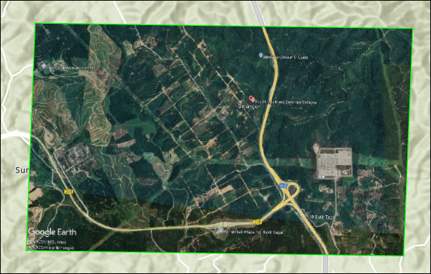
The image below shows that the footprint extent is aligned with the extent of the TIFF image.
Article ID: 000036043
- ArcGIS Pro
Get support with AI
Resolve your issue quickly with the Esri Support AI Chatbot.


Related Information
Discover more on this topic
Search for related information
Find training related to this topic
Explore ideas and give feedback
Get help from ArcGIS experts
Start chatting now