PROBLEM
3D objects appear to float above the surface after using the 3D Scenes Local Government Solution
Description
After running the buildings tasks and applying 3D symbology to the building footprints, the buildings appear to float above the surface or appear sunken below the surface.
Cause
The LIDAR data used to generate the building elevation have different values than the World Elevation Surface.
Solution or Workaround
Follow the instructions provided to position the buildings on the surface correctly:
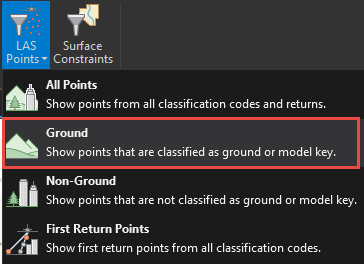
- In ArcGIS Pro, add the LAS dataset to a scene layer.
- Select the layer and click the Appearance tab.
- Under the LAS Points filter, select Ground.
- Run the LAS Dataset To Raster tool.
- Select the LAS dataset layer as the input feature.
- Select Triangulation as the interpolation type.
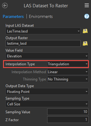
- Click OK. A new raster layer is created.
- Right-click the scene layer and select Properties.
- Go to Elevation Surface and expand the elevation sources section.
- Click Add Elevation Source and select the raster created in Step 4.
- Apply the changes to the scene.
Note:
If there are remaining building parts that appear to be floating above the surface, this is because the original elevation was calculated from the LIDAR.
Article ID: 000017838
- ArcGIS Pro
Get support with AI
Resolve your issue quickly with the Esri Support AI Chatbot.


Related Information
Discover more on this topic
Search for related information
Find training related to this topic
Explore ideas and give feedback
Get help from ArcGIS experts
Start chatting now