HOW TO
Update XY coordinates after moving existing point features in ArcGIS Pro
Summary
In ArcGIS Pro, it is possible to update XY coordinates in the attribute table after moving existing point features to a different location on the map. Tools such as Calculate Field, Calculate Geometry Attributes, and Add XY Coordinates can be used to update these coordinates, providing a flexible and efficient way to keep the XY coordinates accurate and aligned with the updated location of the point features on the map.
This article provides the workflows to update the XY coordinates of moved point features in ArcGIS Pro.
Procedure
Note:
The Calculate Field and Calculate Geometry Attributes tools modify the input data by changing values in the attribute fields. Refer to ArcGIS Pro: Tools that modify or update the input data for more information. To enable undo, toggle the Enable Undo option in the Calculate Field window and the Calculate Geometry Attributes pane before running the tools.
Use the Calculate Field tool to update the XY coordinates
- Open the ArcGIS Pro project.
- In the Contents pane, right-click the point feature layer and click Attribute Table.
- Update the XY coordinates using the Calculate Field tool on the existing fields. In this example, the PointX field stores the X coordinates, and the PointY field stores the Y coordinates.
- In the attribute table, click Calculate. The Calculate Field window opens.
- In the Calculate Field window, for Field Name (Existing or New), select the X coordinate field. PointX is used in this example.
- For Expression Type, select Python.
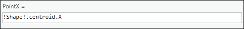
- Under the Expression section, in the expression box, specify the following script:
!Shape!.centroid.X
- Click Verify
 to validate the expression and click Apply.
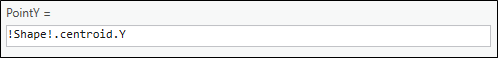
 - Repeat Steps 3(b) through 3(e) in the Calculate Field window for the Y coordinate field using the following script in the expression box:
!Shape!.centroid.Y
- Click OK to close the Calculate Field window.
Use the Calculate Geometry Attributes tool to update the XY coordinates
Update the XY coordinates of the moved point features on new or existing fields using the Calculate Geometry Attributes tool. This tool offers the functionality to select the coordinate format for the output, allowing customization of the coordinates based on specific requirements. Refer to How To: Calculate the XY coordinates of point features in ArcGIS Pro for instructions.
Use the Add XY Coordinates tool to update the XY coordinates
Update the XY coordinates of the moved point features using the Add XY Coordinates tool. This tool modifies the input data by adding new fields with the XY coordinates. Refer to ArcGIS Pro: Add XY Coordinates (Data Management) for more information.
Note:
Alternatively, before moving point features to a different location on the map, create attribute rules to automatically add and update the XY coordinates in the attribute table. Refer to ArcGIS Blog: Get to the Point: Automatically maintain x,y,z attribute values with ArcGIS Pro and attribute rules for instructions.
Article ID: 000034652
- ArcGIS Pro 3 3
- ArcGIS Pro 3 2
- ArcGIS Pro 3 4
Get support with AI
Resolve your issue quickly with the Esri Support AI Chatbot.


Related Information
Discover more on this topic
Search for related information
Find training related to this topic
Explore ideas and give feedback
Get help from ArcGIS experts
Start chatting now