HOW TO
Update existing point features based on new XY coordinates in ArcGIS Pro
Summary
In ArcGIS Pro, the Shape field is a geometry data type that stores the geometry of a feature layer. Modifying the XY coordinates in the attribute table does not automatically update the Shape field. As a result, existing point features do not reflect the new XY coordinates. To ensure the locations of the point features are updated on the map, the Shape field must be updated.
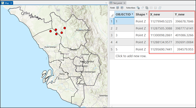
This article provides the workflow to update the existing point features based on the new XY coordinates by configuring the Shape field using the Calculate Field tool. In this example, the XY coordinates are stored in the X_new and Y_new fields. The map below shows the point features with the XY coordinates in the attribute table.
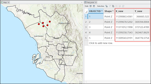
The map below shows the locations of the point features are not updated after modifying the XY coordinates.
Procedure
Note:
The Calculate Field tool modifies the input data by changing values in the attribute fields. Refer to ArcGIS Pro: Tools that modify or update the input data for more information. To enable undo, toggle the Enable Undo option in the Calculate Field window before running the tool.
- Open the ArcGIS Pro project.
- In the Contents pane, right-click the point feature layer and click Attribute Table.
- Configure the Shape field using the Calculate Field tool.
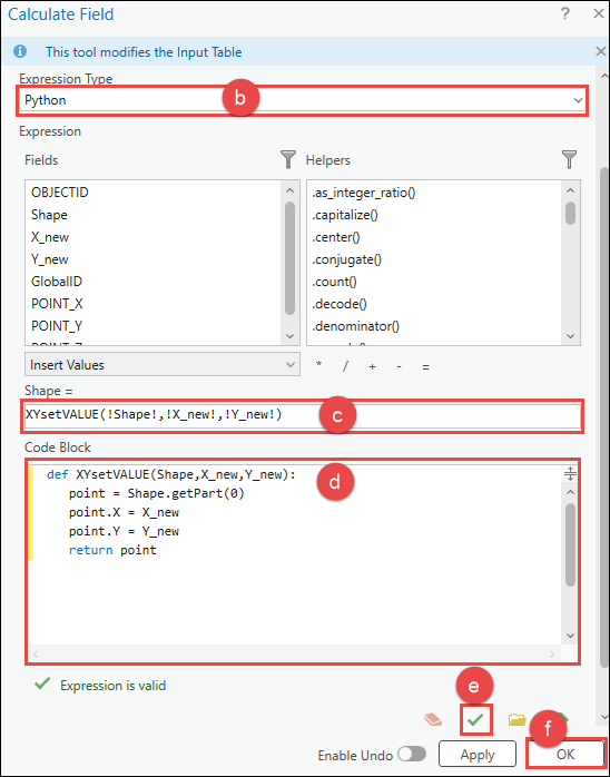
- In the attribute table, right-click the Shape field header and click Calculate Field.
- In the Calculate Field window, for Expression Type, select Python.
- Under the Expression section, specify the following script in the expression box. Replace X_field and Y_field with the fields storing the X and Y coordinates.
XYsetVALUE(!Shape!,!<X_field>!,!<Y_field>!)
- In the Code Block box, specify the following script.
def XYsetVALUE(Shape,<X_field>,<Y_field>):
   point = Shape.getPart(0)
   point.X = <X_field>
   point.Y = <Y_field>
   return point
- Click Verify to validate the expression.
- Click OK.
Note:
Alternatively, use the XY Table To Point tool to create a new point feature layer with the new XY coordinates instead of updating the existing point feature layer. Refer to ArcGIS Pro: Add x,y coordinate data as a layer for instructions.
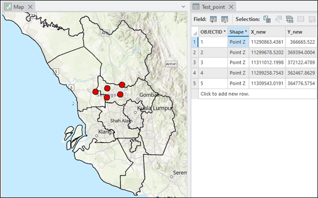
The map below shows the point features are updated to reflect the new XY coordinates after configuring the Shape field.
Article ID: 000034569
- ArcGIS Pro 3 3
- ArcGIS Pro 3 2
- ArcGIS Pro 3 4
Get support with AI
Resolve your issue quickly with the Esri Support AI Chatbot.


Related Information
Discover more on this topic
Search for related information
Find training related to this topic
Explore ideas and give feedback
Get help from ArcGIS experts
Start chatting now