HOW TO
Understand time-enabled services in ArcGIS Online
Summary
This article is intended to provide some clarity to the below questions.
- Are you experiencing issues with setting up a time-slider for a WMS layer (or other type of layer) in an ArcGIS Online web map?
- Are you looking to understand the units and behavior of a time-enabled service used in your projects?
- Is the service you are accessing capable of using a time slider?
Procedure
How to time-enable a layer in ArcGIS Online
If a layer has the appropriate time-related fields, to enable a time slider, refer to the video in this ArcGIS blog for guidance: Time-Enable a Layer in ArcGIS Online
The steps are as follows:
- Go to the item details page for the feature service/WMTS/WFS, etc., in question and select the specific layer in which to enable time.
- In the Overview tab, find the Time Settings toggle box, and select the Edit button.
- Toggle on for Enable time and select the relevant field and settings required.
- Select OK.
If these settings weren't automatically applied, the layer now enables the time slider within a web map.
Is your layer time-enabled?
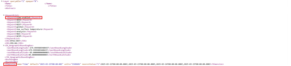
To check whether a layer is time-enabled, head to the metadata for the service, by using the GetCapabilities link, as in the below publicly available WMS:
Use 'control find' (Ctrl-F) to search for terms such as 'time' or 'dimension'.
In OGC WMS (Web Map Service) standards, a dimension refers to an additional variable that can be used to request specific subsets of a map layer, beyond just the spatial (X/Y) and style parameters. This is often in the form of time, or perhaps elevation.
For one of these services to interface with time-based functionality in ArcGIS Online, they must have the time dimension listed, and for the configuration to be compatible with ArcGIS. An OGC compliant service will work, and the structure of this dimension is shown in the images below with further discussion.
What do these terms mean?
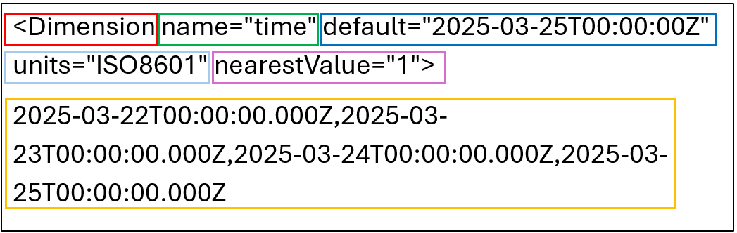
- Dimension – This element in the WMS GetCapabilities document provides information about a time dimension, it is used to describe the time values available for the WMS service.
- name=”time” – This specifies that the dimension being defined is time, indicating that this <dimension> element is related to time-based data.
- default=”2025-03-25T00:00:00Z” – This defines the default time value when the layer is first displayed in the application, such as ArcGIS Online Map Viewer. This is represented in ISO 8601 format. The Z indicates that the time is in UTC.
- units=”ISO8601” – This specifies that the time values in the dimension are provided in ISO 8601 format, which is typically the standard for representing date and time, and presents time-units from largest to smallest
- nearestValue=”1” – This means that when a user selects a time that is not exactly one of the available time values, the nearest available time is used. This is usually set to “1”, if it is set to “0” the system requires the user to select the exact accepted units.
- Time Values – These are the available time steps or time intervals that the WMS service supports. This specific example lists four dates: March 22, March 23, March 24, and March 25, 2025.
What If the Layer Doesn’t Support Time Settings?
There are cases where a layer does not support time settings in ArcGIS Online. This typically occurs when the layer lacks temporal information in its metadata or schema. In such situations:
- The Time Settings option does appear in the layer’s item details page.
- Attempting to configure the time slider is not possible because the service is not recognized as time-enabled.
- The absence of <Dimension name="time"> or equivalent time fields in the service metadata confirms this limitation.
This limitation may be due to:
- The data publisher not including time fields during publishing.
- The data being inherently static, for example, base maps or reference layers.
- WMS or other services not conforming to expected OGC time standards.
More information can be found in the following Esri Knowledge Base article:
Problem: The Time Settings Option is Not Available in ArcGIS Online
For more information on OGC WMS standards, find detailed information about the <Dimension> element and its use in time-enabled WMS services at: https://www.opengeospatial.org/standards/wms
Article ID: 000037685
- ArcGIS Online
Get support with AI
Resolve your issue quickly with the Esri Support AI Chatbot.


Discover more on this topic
Search for related information
Find training related to this topic
Explore ideas and give feedback
Get help from ArcGIS experts
Start chatting now