HOW TO
Split a polygon by percentage via ArcPy in ArcGIS Pro
Summary
ArcGIS Pro allows splitting a polygon feature into several segments by using tools such as the Split (Analysis) tool and the Split tool from the Modify Features pane. However, the tools provided are unable to split the polygon by percentage. Follow the steps provided in this article to split a polygon by percentage in the Python window.
Procedure
Note:
Ensure the data added to the map and the map share the same projected coordinate system to avoid errors.
- Import the ArcPy module and configure the environment of the script.
Import arcpy
p = arcpy.mp.ArcGISProject("CURRENT")
m = p.listMaps("<Map_Name>")[0]
lyr = m.listLayers(0)
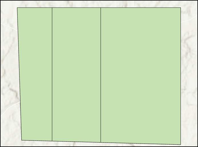
- Specify the polygon split percentage using an array parameter. In this example, the polygon is split by 20%, 30%, and 50%.
splits = [20, 30, 50]
- Retrieve the polygon and the polygon extent properties using the SearchCursor function.
with arcpy.da.SearchCursor("<Layer_Name>", ["SHAPE@"]) as pcursor:
   for prow in pcursor:
      polygon = prow[0]    # polygon to cut
      e = polygon.extent   # bounding extent of polygon
      print(e.XMin,e.YMin,e.XMax,e.YMax)
del pcursor
- Create a variable to store the geometric iteration accuracy value.
stepsize = 0.001
- Specify the parameters to set the polygon split direction.
leftXstart = e.XMin
leftX = e.XMin + stepsize
ymax = e.YMax
ymin = e.YMin
- Iterate through the polygon cut process using the cut() function according to the split percentages set in Step 2.
cutpoly = polygon
icursor = arcpy.da.InsertCursor("<Layer_Name>", ["SHAPE@"])
for i in splits[:2]:
   print(i)
   tol = 0
   while tol < i:
      # construct NS line
      pntarray = arcpy.Array()
      pntarray.add(arcpy.Point(leftX, ymax))
      pntarray.add(arcpy.Point(leftX, ymin))
      pline = arcpy.Polyline(pntarray,arcpy.SpatialReference(<WKID>))
      # cut polygon and get split-parts
      cutlist = cutpoly.cut(pline)
      tol = 100 * cutlist[1].area / polygon.area
      leftX += stepsize
      #print str(leftX) + ":" + str(tol)
   cutpoly = cutlist[0]
   icursor.insertRow([cutlist[1]])
# part 0 is on the right and part 1 is on the left of the split
- Insert the last split remainder.
icursor.insertRow([cutlist[0]])
del icursor
The code below shows the full working script.
Import arcpy
p = arcpy.mp.ArcGISProject("CURRENT")
m = p.listMaps("Map")[0]
lyr = m.listLayers(0)
splits = [20, 30, 50]
with arcpy.da.SearchCursor("testpolygon", ["SHAPE@"]) as pcursor:
   for prow in pcursor:
      polygon = prow[0]
      e = polygon.extent
      print(e.XMin,e.YMin,e.XMax,e.YMax)
del pcursor
stepsize = 0.001
leftXstart = e.XMin
leftX = e.XMin + stepsize
ymax = e.YMax
ymin = e.YMin
cutpoly = polygon
icursor = arcpy.da.InsertCursor("testpolygon", ["SHAPE@"])
for i in splits[:2]:
   print(i)
   tol = 0
   while tol < i:
      pntarray = arcpy.Array()
      pntarray.add(arcpy.Point(leftX, ymax))
      pntarray.add(arcpy.Point(leftX, ymin))
      pline = arcpy.Polyline(pntarray,arcpy.SpatialReference(3857))
      cutlist = cutpoly.cut(pline)
      tol = 100 * cutlist[1].area / polygon.area
      leftX += stepsize
   cutpoly = cutlist[0]
   icursor.insertRow([cutlist[1]])
icursor.insertRow([cutlist[0]])
del icursor
The image below demonstrates the polygon split by 20%, 30%, and 50% after running the Python script in ArcGIS Pro.
Article ID: 000027999
- ArcGIS Pro 3 0
- ArcGIS Pro 2 8 x
- ArcGIS Pro 2 x
Get support with AI
Resolve your issue quickly with the Esri Support AI Chatbot.


Related Information
Discover more on this topic
Search for related information
Find training related to this topic
Explore ideas and give feedback
Get help from ArcGIS experts
Start chatting now