HOW TO
Measure the length of curved lines in ArcGIS Pro
Summary
In ArcGIS Pro, curved lines are common in land parcels, roadways, and other features where boundaries follow curved paths instead of straight lines. These curves are often found in various applications, such as cadastral mapping, engineering designs, and environmental studies, where precise measurements are required for accurate modeling and navigation.
This article describes several workflows to measure the length of curved lines in ArcGIS Pro.
Procedure
Use the Circular Arc tool
A curve is created using the Circular Arc tool by drawing a line or polygon feature between the start and end points of the arc to measure the existing curve length. The tool calculates and displays the arc length of the curve.
Note:
This method only displays the length without permanently saving the value in the attribute table. This is suitable for quick identification of a specific curved line.
- Open the ArcGIS Pro project.
- On the Edit tab, in the Features group, click Create.
- In the Create Features pane, select the polygon or line feature template with the curve.
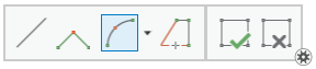
- On the construction toolbar, click the arcs and curves drop-down arrow and click the End Point Arc Segment tool.
- Turn snapping on and enable the Endpoint snap agent. Refer to ArcGIS Pro: Enable snap agents for instructions.
- In the map view, click the start point of the arc.
- Click the endpoint of the arc.
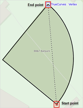
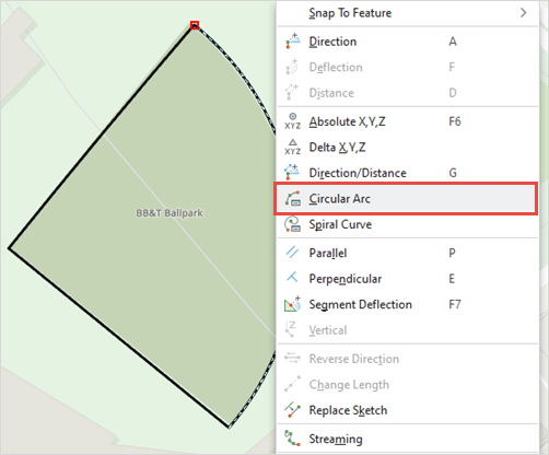
- Move the pointer to the existing curve until it snaps, right-click, and select Circular Arc.
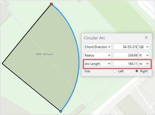
The map below shows a preview of the arc as a blue line, with the corresponding arc length calculated and displayed in the Circular Arc dialog box.
- Close the Circular Arc dialog box. On the construction toolbar, click Cancel to exit editing mode.
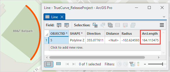
Enable COGO for the line feature class and use the Update COGO tool
In ArcGIS Pro, coordinate geometry (COGO) is used to define the geometric properties of lines and curves such as the radius, angle, arc length, and chord direction. When working with curved lines, enabling COGO updates the curve attributes, including its length, and calculates its geometric parameters. Once COGO is enabled, use the Update COGO tool to update the attributes of the curved lines.
- Open the ArcGIS Pro project.
- Enable COGO for the line feature class. Refer to ArcGIS Pro: Enable COGO for a line feature class for instructions.
- In the Geoprocessing pane, search for and click the Update COGO tool.
- On the Parameters tab of the Update COGO pane, configure the parameters below.
- For Input Line Features, select the line feature layer.
- For Update Distance, Radius, and Arc Length, select Overwrite all values.
- Click Run.
- In the Contents pane, right-click the line feature layer and select Attribute Table.
The attribute table below displays the arc length for the COGO-enabled line feature class in ArcGIS Pro.
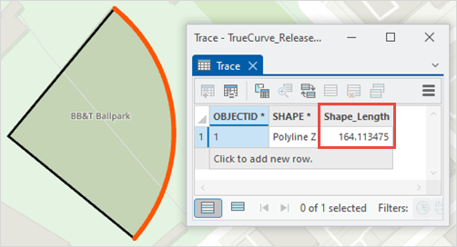
Use the Trace tool to calculate curves on existing polygon features
In this workflow, a new line feature class is created to trace the existing curve using the Trace tool. The length of the traced curve is calculated and stored in the Shape_Length field of the line feature layer.
- Open the ArcGIS Pro project.
- Create a line feature class. Refer to ArcGIS Pro: Create a stand-alone feature class for instructions.
- Trace the curved line using the newly created line feature class. Refer to ArcGIS Pro: Trace for instructions.
- In the Contents pane, right-click the line feature layer and select Attribute Table.
The attribute table below displays the length of the traced curve calculated for the line feature class in the Shape_Length field.
Article ID: 000034412
- ArcGIS Pro 3 3
- ArcGIS Pro 3 2
- ArcGIS Pro 3 4
Get support with AI
Resolve your issue quickly with the Esri Support AI Chatbot.


Related Information
Discover more on this topic
Search for related information
Find training related to this topic
Explore ideas and give feedback
Get help from ArcGIS experts
Start chatting now