HOW TO
Import a MapInfo Interchange Format file into ArcGIS Pro
Summary
A MapInfo Interchange Format (MIF) file is a map file and database exporting file format containing boundary objects, (for example, areas, curves, and points) and associated information such as color, thickness, and style. However, MIF files are not supported in ArcGIS Pro, but the files can be imported into ArcGIS Pro as geodatabase files. This article describes the workflow to import a MIF file into ArcGIS Pro.
Procedure
Note:
The Quick Import tool requires the ArcGIS Data Interoperability extension and the Data Interoperability license. Refer to ArcGIS Pro: Installing the ArcGIS Data Interoperability extension to install the ArcGIS Data Interoperability extension in ArcGIS Pro, and ArcGIS Pro: Authorize extension licenses to assign the extension license.
- Open a new project in ArcGIS Pro. Refer to ArcGIS Pro: Create a project for instructions.
- In the Geoprocessing pane, search for and click the Quick Import tool. Refer to ArcGIS Pro: Run a tool in the Geoprocessing pane for instructions.
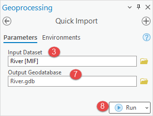
- In the Quick Import pane, click the Parameters tab, and for Input Dataset, click Browse
 .
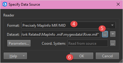
. - In the Specify Data Source dialog box, search for and select Precisely MapInfo MIF/MID from the Format drop-down list.
Note:
Optionally, click More Formats…, search for and select Precisely MapInfo MIF/MID from the format list in the FME Reader Gallery dialog box, and click OK.
- For Dataset, click Open file browser
 , and select the MIF file from the Select 'File' dialog box.
Note: To select multiple files or folders, or files from the web, click the Open file browsermenu, and select Select Multiple Folders/Files… or Select File From Web.
- Click OK.
- In the Quick Import pane, provide a name for Output Geodatabase, and click Browse
 to specify the location of the file geodatabase.
 - Click Run.
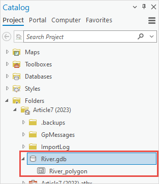
The image below shows the file geodatabase imported from the MIF file into ArcGIS Pro.
Article ID: 000029745
- ArcGIS Pro 3 1
- ArcGIS Pro 3 0
- ArcGIS Pro 2 x
Get support with AI
Resolve your issue quickly with the Esri Support AI Chatbot.


Related Information
Discover more on this topic
Search for related information
Find training related to this topic
Explore ideas and give feedback
Get help from ArcGIS experts
Start chatting now