HOW TO
Generate a map series for multiple linear paths in ArcGIS Pro
Summary
In some cases, when mapping extensive linear paths (routes, hydrological networks, or pipelines), it is necessary to combine them into one single output before creating a map series. A map series is a collection of map pages created from a single layout, where each page shows a specific geographic area based on an index layer. Therefore, creating a map series effectively visualizes long, linear features on different pages, making it ideal for field inspections, infrastructure monitoring, and route analysis tasks. This article provides a workflow to create a map series for multiple linear paths using ArcGIS Pro.

Procedure
- Open the ArcGIS Pro project.
Note:
For instructions to find and use the geoprocessing tool, refer to ArcGIS Pro: Find a geoprocessing tool.
- Combine multiple linear paths or line features into a single output feature layer using the Merge tool.
- Create a series of polygons along the path using the Strip Map Index Features tool.
- In the Strip Map Index Features pane, for Input Line Features, select the output from Step 2 in the drop-down list.
- For Output Feature Class, specify a name.
- Check the Use Page Unit and Scale check box and specify the preferred scale, or leave the default scale for Map Scale.
- For Percentage of Overlap, specify the acceptable overlapping map pages. In this example, '2' is specified.
- For Strip Map Direction, specify the initial direction of the strip maps. In this example, East to West and North to South is specified.
- Click Run.

Note:
Optionally, apply the symbology to the polygon features to improve visualization. Refer to ArcGIS Pro: Apply symbology to feature layers for instructions.
- Enable labeling for the polygon features. Refer to ArcGIS Pro: Turn on labels for instructions.
- Change the current map view to layout view. Ensure that the page orientation is set to landscape, if required. Refer to ArcGIS Pro: Create a blank layout and ArcGIS Pro: Change the layout page orientation for instructions.
- Display a series of polygon features on each page using a spatial map series.
- On the Insert tab, in the Map Frames group, click Map Frame to add the desired map frame to the layout. Refer to ArcGIS Pro: Insert a map frame for more information.
- In the Map Frames group, click Map Series, and select Spatial from the drop-down list.
- In the Layout Properties window, click Map Series > Optional Fields. For Rotation, select Angle.
- For Map Extent, click Center and Mantain Scale. Specify a preferred extent that matches the strip index. In this example, 1:1000 is specified.
- Click OK.
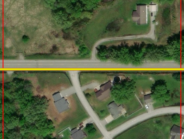
The image below shows a single page of the map series for one strip index feature.
Article ID: 000035759
- ArcGIS Pro
Get support with AI
Resolve your issue quickly with the Esri Support AI Chatbot.


Related Information
Discover more on this topic
Search for related information
Find training related to this topic
Explore ideas and give feedback
Get help from ArcGIS experts
Start chatting now